Apple Maps
By MacRumors Staff
Apple Maps How Tos
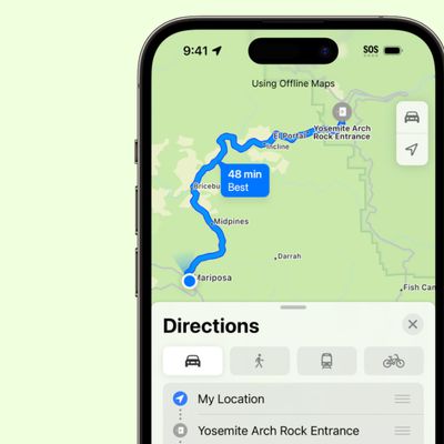
iOS 17: How to Download Offline Maps in Apple Maps
In iOS 17, Apple has added the ability to download Maps for use offline, providing access to turn-by-turn directions and information for a chosen area even if you do not have a cellular or Wi-Fi connection. Keep reading to learn how it's done. Apple Maps is catching up with Google Maps in iOS 17 by finally letting iPhone users download maps for offline use. Thanks to the new feature, you...
Read Full Article
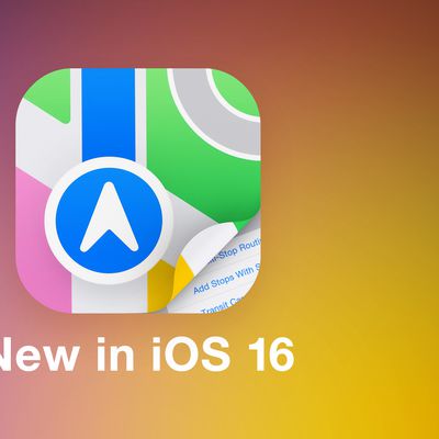
iOS 16: How to Use Multi-Stop Routing in Maps
In iOS 16, Apple Maps has received an update that brings multi-stop routing to the navigation app. Keep reading to learn how to use it. With iOS 16, the Maps app allows you to plan a route that has multiple stops instead of just a single destination. While Google Maps has had this feature for some time, this is the first version of Apple's Maps app to include support for it. When entering ...
How to Get a List of Directions in Apple Maps
After several years of iterations and improvements, Apple Maps has become a solid app and a viable Google Maps alternative for getting GPS-based directions to navigate journeys by car, public transport, bicycle, and on foot. Depending on the journey though, you may want to print off a list of turn-by-turn directions to refer to instead of relying on your iPhone and draining the battery. Or...
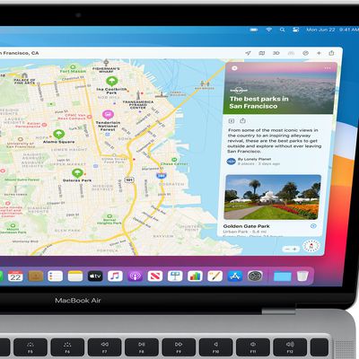
iOS 15: How to Find Fun Things to Do With the Dedicated Apple Maps Guide Section
In iOS 15, has brought several major improvements to the Maps app, with better driving directions, improved transit directions, and more immersive AR-based walking directions. In addition, Apple has added a dedicated Guides Home that houses editorially curated guides with tips on what to do in a city where you live or where you're visiting. To explore Apple's guides at any time in the...
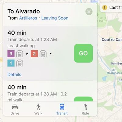
iOS 15: How to Find Transit Stations Near You in Apple Maps
In iOS 15, Apple's Maps app benefits from a range of new features and improvements, including the ability get real-time information on the nearby transit options available to you. This transit information can be found for major bus routes and rail lines in cities with updated maps. Transit riders can see all of the departures listed near them, including any existing delays on services, and...
iOS 15: How to Get AR Walking Directions in Maps
In iOS 15, Apple's Maps app benefits from a range of new features and improvements, including the ability to use augmented reality walking directions in big cities. In a nod to Google Maps, the new AR mode can map walking directions onto the real world by using your iPhone's rear camera, making it easier to see where you need to go in built-up areas and reducing the need to look down at your ...
iOS 15: How to Find User Settings in Maps
In iOS 15, Apple has added a user account area in the Maps app that corrals several custom areas like direction mode, toll and highway avoidance options, transit options, and more. To access it, simply tap the circular icon to the immediately to the right of the search bar. You should see your initials within the circle, indicating it's your account. A new menu card will pop up with...
iOS 15: How to Filter Search Results in Maps
In iOS 15, Apple has worked to improve the search results in its Maps app, and has added the ability to filter results by options like what specific cuisine you're looking for, whether a restaurant is open or offers takeout, and more. In the following steps, we've demonstrated how it works by looking for restaurants that serve a particular type of cuisine, but you can filter other...
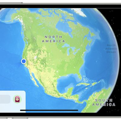
iOS 15: How to Use the Interactive Maps Globe
In iOS 15, Apple has enhanced the Maps app to include a new globe view that allows you to spin the world around and zoom into different regions on Earth. In previous versions of iOS, zooming out maximally in Maps would present you with a flat world map, but the new globe view gives you a three-dimensional view of Earth from space that's a lot more fun to navigate. It's easier, too –...
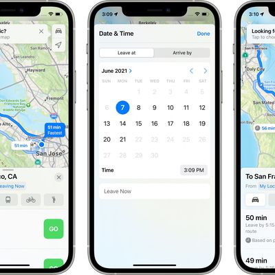
iOS 15: How to Set Leaving and Arrival Times for Driving Directions in Apple Maps
Apple Maps received several notable improvements in iOS 15, including new details in cities, an interactive globe, and enhanced driving directions. It also gained a feature that has long been available in rival map apps – the ability to set leaving and arrival times for driving directions. This is a feature that's long been available for Google Maps, and one that's really useful if you...

iOS 14.5: How to Report Speed Checks, Traffic Accidents, and Other Hazards in Apple Maps
In iOS 14.5 and later, Apple has added a Waze-like feature to its native Maps app that lets you report accidents, hazards, and speed checks along your route when getting directions. Keep reading to learn how it works. Driving on public roads can throw up all sorts of hazards, but if you're given prior warning then you can be better prepared to deal with them. Apple recognizes this, which is...
How to Clear Your Location History in Apple Maps
When you search a location in Apple Maps on iOS and Mac, the app conveniently remembers your search in case you want to return to it at a later time. However whether for housekeeping or privacy reasons, you can quickly and easily remove your Maps search history at any time. Keep reading to learn how its done. Delete Apple Maps History on iPhone and iPad Launch Apple's Maps app on your...
iOS 14: How to Use Guides in Apple Maps
In iOS 14, Apple's Maps app got a handful of new features and refinements, one of which is the ability to explore places with the help of Guides. Guides provide recommendations for the best places to visit in a city, offering up suggestions on places to eat, shop, and explore. Some of Apple's partners for these Guides include Lonely Planet, the Washington Post, AllTrails, The Infatuation, and ...
iOS 14: How to Get Cycling Directions in Apple Maps
Google Maps has featured detailed cycling directions for almost a decade now, and with the arrival of iOS 14, Apple Maps is finally introducing its own. The steps below show you how to make use of the new cycling directions in Apple's Maps app. If you have an Apple Watch running watchOS 7 or later, you can receive the directions you select right on your wrist, for easy at-a-glance navigation. ...

How to Ask Siri to Share Your ETA When Navigating With Apple Maps
In iOS 14, Apple has greatly expanded the number of direct answers Siri can give you. The majority of these answers are thanks to enhanced web-based information, but some of it is also down to Siri's tighter integration with other Apple apps. For example, the Apple Maps app lets you share your estimated time of arrival when you're following turn-based driving directions, and now you can ask ...
How to Share Your Estimated Time of Arrival in Apple Maps
In the latest version of Apple Maps that comes with iOS 13, Apple has added a Share ETA feature that lets you share your estimated time of arrival at a location with a friend or family member, allowing them to follow your progress in real-time for the duration of the trip. The following steps explain how to use the Share ETA feature in Apple Maps on iPhone and iPad. Note that Apple nixed the...
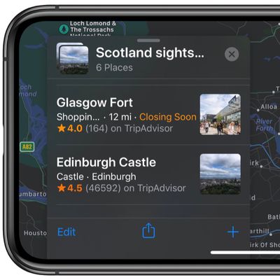
How to Create a Collection in Apple Maps
In iOS 13, Apple added a Collections feature to its Maps app on iPhone and iPad that lets you search for and aggregate lists of different locations, such as restaurants you're thinking of eating out at, sightseeing locations for when you're on vacation, or other places you want to visit. Collection lists can also be shared, so you can create lists of places for friends and family that will...
How to Send Feedback About Errors in Apple Maps
In iOS 13, Apple introduced a redesigned customer feedback process for its Apple Maps app which is designed to make it easier for users to submit corrections for things like incorrect addresses, business locations, or operating hours. If you find an error or something that needs updating in Apple's maps information, you can now send the correct details in just a few quick taps. The following...
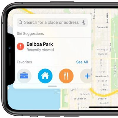
How to Add Places to Your Favorites in Apple Maps
In the latest version of Apple Maps that comes with iOS 13, Apple has added a Favorites feature that lets you search for specific places and then add them to a list. Favorites are meant for places that you visit frequently, and Home and Work are already added by default. Any place you frequent can be added to the Favorites list, such as a favorite restaurant or coffee shop, or a friend or...
How to Use Look Around in Apple Maps
With iOS 13, Apple introduced several additional features to its Maps app, one of which is called Look Around. This gives you a street-level view of what's around your current location or the location you search for on the map. If you've ever used Google Street View, you already have a good idea of how Look Around works, but Apple's equivalent feature includes a couple of functions that...

What's New in Maps in iOS 11: Indoor Mapping, Lane Guidance and Speed Limits
The Maps app in iOS 11 is outfitted with several new features that significantly improve the app's functionality. Indoor maps let you find restaurants, bathrooms, and other locations in airports and malls, while other new features like speed limits and lane guidance improve turn-by-turn directions. Fun fact: In iOS 11, Apple has also updated the Maps icon. The new version is meant to show off...
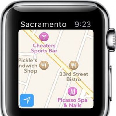
How to Use Apple Watch to Get Directions
Apple Watch includes a miniature version of Apple Maps, which offers many of the same features as the full iOS version if you know how to access them. Some of what Maps can do is fairly obvious, but there are a few features that require a bit more know-how. If you are interested in learning the ins and outs of Apple Maps on Watch OS and would like to know some simple tips for getting the most...
Apple Maps Guides
Apple Maps: Complete Guide to iOS 13
Apple introduced updates to many of the built-in iOS apps in iOS 13, and Maps is no exception. The updated version of Maps has a long list of new features that are designed to make the Apple Maps app better able to compete with mapping apps from other companies. There's a new Look Around street view level feature, a Collections feature for aggregating lists of your favorite places, a...
Apple Maps Articles

Apple Maps Transit Directions Now Available in Tucson, Arizona
Apple recently updated its Maps app to add transit directions and data for Tucson, Arizona. Transit directions have been available in Phoenix, Arizona since October of 2017, but transit information for Tucson appears to be new. Apple Maps users in Tucson can now select public transportation routes when getting directions between two locations, with SunTran bus lines available as a transit...
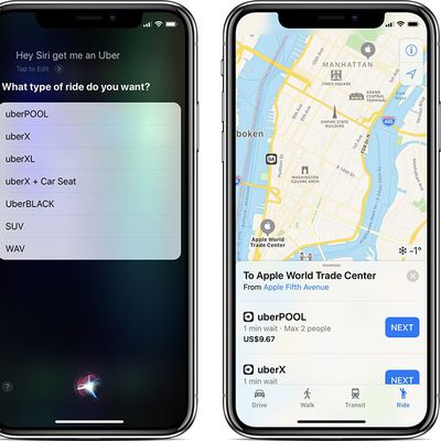
Uber's Latest App Update Restores Siri and Apple Maps Integrations
Uber yesterday updated its iPhone app, and while the release notes do not mention any specific changes, the latest version appears to re-enable the ability to request a vehicle for pickup using Siri or Apple Maps. After updating the Uber app, we were successfully able to ask Siri to hail us a ride, while tapping on the Ride tab in Apple Maps once again listed Uber as one of the ride-hailing...

Uber's Siri and Apple Maps Integrations Have Disappeared
Uber's latest app update appears to have removed several important iOS integrations, with the service now unavailable to both Siri and Apple Maps. If you ask Siri to get you an Uber, a feature that has been available since the launch of iOS 10, Siri will say that Uber hasn't activated that feature. In the "Siri & Search" section of the Uber options in the Settings app, there's also no longer a ...

Apple Maps Transit Directions Now Available in Milwaukee, Wisconsin and Omaha, Nebraska
Apple recently updated its Maps app to add transit directions and data for Milwaukee, Wisconsin and Omaha, Nebraska, two places where transit information was not previously available outside of Amtrak routes. Apple Maps users in Milwaukee and Omaha can now select public transportation routes when getting directions between two locations, with bus lines available in both areas. Apple has...
iOS 11 Indoor Maps Feature Now Available at More Than 40 Airports and Malls
Starting in iOS 11, Apple introduced support for indoor maps for select malls and airports around the world. Indoor maps have been slow to roll out, but Apple has been steadily adding additional mall and airport maps since September. Apple today began listing indoor maps for malls and airports on its iOS 11 feature availability page, giving us a clear picture of exactly where the indoor...

Apple Maps Transit Directions Available in Tampa, Florida
Apple recently updated its Maps app to add transit directions and data for Tampa, Florida, according to Apple's iOS 11 Feature Availability website. Transit directions have been available in Miami, Florida since mid-2016, but have not expanded to other areas of the state. Transit options available in Tampa include the TECO Line Streetcar System, several bus lines, and Amtrak, which connects to ...
Apple Maps Lane Guidance Expanding to Five More Countries
Apple Maps now provides lane guidance in five additional countries, including Australia, Canada, France, Germany, and the United Kingdom. Apple Maps lane guidance on CarPlay in UK (Photo: Drew Post via Twitter) While navigating with Apple Maps via iPhone or CarPlay in those countries, a set of directional arrows will now appear at the top of the screen that indicate which lane your vehicle...
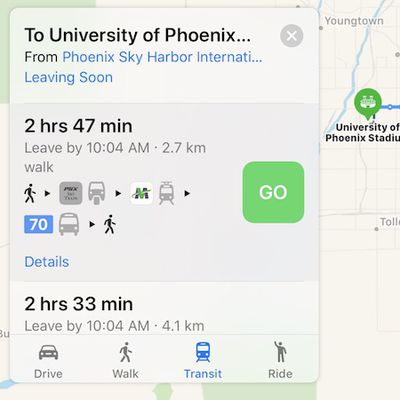
Apple Maps Transit Directions Now Available in Phoenix and Birmingham, AL Areas
Apple Maps has been updated with comprehensive transit data in the Phoenix, Arizona and Birmingham, Alabama areas, enabling navigation with public transportation options such as buses and trains in those regions. In the Phoenix area, supported vehicles include Valley Metro buses and trains, and the PHX Sky Train at Phoenix Sky Harbor International Airport. Routes extend to and from suburbs...
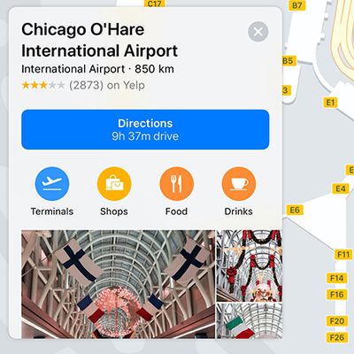
Apple Continues Rolling Out Indoor Maps of Airports in iOS 11
Apple Maps now provides indoor maps for eight additional airports in the United States, as the new feature continues to roll out in iOS 11. The recently added airports include O'Hare International and Midway International in Chicago, McCarran International in Las Vegas, Baltimore–Washington International, Miami International, Minneapolis–Saint Paul International, Oakland International,...
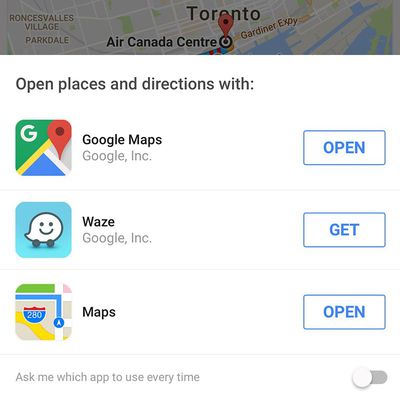
Google App Now Lets You Get Directions With Apple Maps or Waze
Google's official search app for iOS has been updated this week with more navigation options in the United States and other countries. In addition to Google Maps, you can now use Apple Maps or Waze for navigation when searching for places and addresses in the Google app. When you search for an address and tap the navigation button, a menu opens with the three options for directions:...
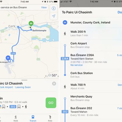
Apple Maps Transit Directions Expand to Ireland
Apple Maps has added public transit directions for Ireland, as pointed out by developer Steven Troughton-Smith on Twitter. With the updated directions, users in Ireland can now choose from a few different public transportation routes when traveling around Ireland. Transit directions are available in a few cities like Dublin and Cork, including transportation provided by Bus Éirann, Aircoach,...
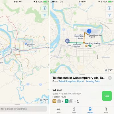
Apple Maps Transit Directions Now Available in Taiwan
Apple recently updated its Maps app to add transit directions and data for Taiwan, one of the locations where hints of transit support surfaced months ago. Maps users in Taiwan can now select public transportation routes when navigating across the country, with transit options available in Taipei, Kaohsiung, and other cities. Support is available for the Taiwan Railway and Taiwan High...

Apple Maps Vehicles to Begin Surveying Scotland and Wales [Updated]
Apple Maps vehicles will begin surveying Scotland and Wales for the first time starting in early October. Apple Maps vehicle via MacRumors reader Dieter A. The sensor-laden vehicles will start collecting mapping data in Fort William, a town in the western Scottish Highlands, between October 9 and November 5, according to a recently updated list of driving locations on Apple's website. In...
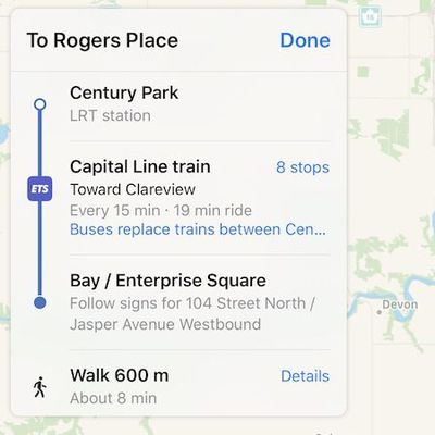
Apple Maps Transit Directions Now Available in Ottawa, Edmonton, and Québec City
Apple Maps has been updated with comprehensive transit data in the Edmonton, Alberta area, enabling iPhone users in Canada's fifth most populous city to navigate with public transportation, including buses and trains. Apple Maps can provide routes for both Edmonton Transit System (ETS) buses and Edmonton Light Rail Transit (LRT) trains throughout the Edmonton area, including to and from the...

Apple Maps Transit Directions Now Available in Hungary
Apple Maps has been updated with transit data in Hungary, enabling iPhone users to navigate with public transportation directions in Budapest, Debrecen, Szeged, Miskolc, Győr, Pécs, and other regions of the country. In the Budapest metropolitan area, supported vehicles include the Budapest Metro, BKV buses and trams, and BHÉV trains. MÁV-START trains are also supported throughout Hungary ...
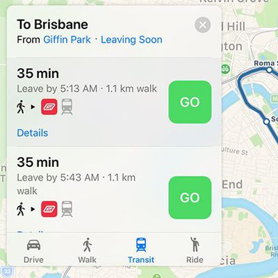
Apple Maps Transit Directions Expand to Brisbane, Perth, and Surrounding Areas in Australia
Apple Maps has been updated with transit data in Queensland and Western Australia, enabling iPhone users to navigate with public transportation directions in large cities such as Brisbane and Perth, and surrounding areas. In Brisbane, supported vehicles include TransLink buses and Queensland Rail trains, with routes extending to, from, and within the Gold Coast and Sunshine Coast suburbs....
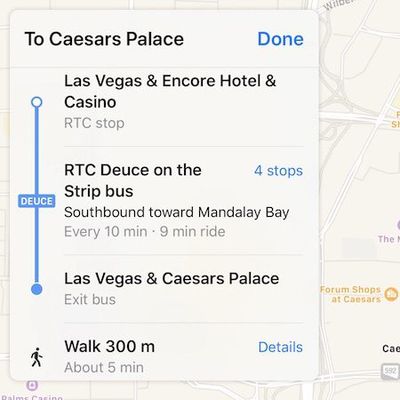
Apple Maps Transit Directions Now Available in Las Vegas and Western Nevada
Apple Maps has been updated with comprehensive transit data in several higher populated areas of Nevada, enabling iPhone users to navigate with public transportation directions throughout the Silver State. Newly supported areas include Las Vegas, including the nearby cities of North Las Vegas and Henderson, as well as the state capital Carson City and the Reno-Sparks metropolitan area in...

Apple Begins Surveying Spain With Mapping Vehicles
Since 2015, Apple has been using LIDAR-equipped mapping vehicles to capture street-level imagery for the Apple Maps app. Apple has expanded the areas where it is collecting data several times over the course of the last two years, and according to the latest update to the company's support page, Apple Maps vehicles have recently made their way into Spain. Apple regularly highlights the...
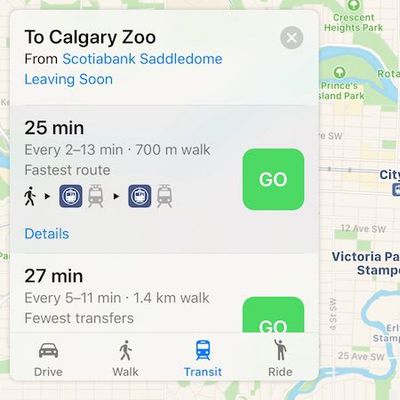
Apple Maps Transit Directions Now Available in Calgary and Southern Alberta
Apple Maps has been updated with comprehensive transit data in Calgary, Alberta, enabling iPhone users in the Canadian city to navigate with public transportation, including the CTrain light rail system and buses. Apple Maps transit directions are also available for buses in the smaller Southern Alberta cities of Red Deer, Lethbridge, and Medicine Hat. Apple Maps enabled transit routing...
Apple Maps Transit Directions Start Rolling Out in Madrid
Apple recently updated its Maps app to add transit directions and data for Madrid, Spain, one of the cities where hints of transit support first surfaced months ago. When searching for directions in Madrid, transit options that include the Empresa Municipal de Transportes de Madrid bus line, the Cercanías Madrid, and the Madrid Metro are now available. Madrid does not, however, have full...