
Apple Continues Rolling Out Indoor Maps of Airports in iOS 11 - MacRumors
Skip to Content

Apple Continues Rolling Out Indoor Maps of Airports in iOS 11

by

Apple Maps now provides indoor maps for eight additional airports in the United States, as the new feature continues to roll out in iOS 11.
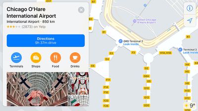
ohare
The recently added airports include O'Hare International and Midway International in Chicago, McCarran International in Las Vegas, Baltimore–Washington International, Miami International, Minneapolis–Saint Paul International, Oakland International, and Portland International.

The feature has also been available for Philadelphia International Airport and San Jose International Airport since iOS 11 was in beta.

When searching for these airports, Apple Maps users can tap "look inside" or simply zoom in to view terminals, boarding gates, security checkpoints, airline check-in desks, baggage claim carousels, information kiosks, restrooms, stores, restaurants, parking garages, and even escalators, elevators, and stairs.
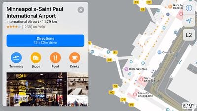
min airport
It is even possible to browse by floor, or search for shops, food, drinks, or restrooms in a specific terminal. Tapping on a restaurant, for example, brings up a detailed place card with photos, hours, and additional information.

Apple software engineering chief Craig Federighi previewed Apple's indoor maps at its Worldwide Developers Conference in June. Skip to around the 1:07:50 mark of Apple's WWDC 2017 keynote video to watch.


Apple said indoor maps will also be available at several other major airports, including Los Angeles International, JFK and LaGuardia in New York, San Diego International, Toronto Pearson International, Vancouver International, Heathrow and Gatwick in London, and Amsterdam Airport Schiphol.

Apple is also adding indoor maps to shopping malls, making it easier to find the exact location of stores, restaurants, restrooms, escalators, elevators, and stairs on each floor. Users can also filter stores by categories such as clothes, shoes, accessories, beauty, food, and drinks, with detailed place cards for each.

A few shopping malls currently supported include Westfield's Valley Fair in San Jose and the San Francisco Centre.

(Thanks, Abel La O Fernandez!)
Top Rated Comments

Mike MA Avatar
116 months ago
Why is Atlanta, the busiest airport in the country and occasionally the world not included in this list? Too big for Apple to map?
Because the service just started rolling out?
Score: 8 Votes (Like | Disagree)
116 months ago
That's not a valid excuse.

ATL is the world's busiest airport (and has been for several years now). If Apple wanted to make the airport mapping useful to a larger percentage of its user base, they would start with the airports that have the highest volume and work their way down to smaller airports.

Apple might eventually catch up with Google in the mapping department in 5 or 10 years. Until then, I guess I'll just keep using Google Maps (which has had ATL mapped in detail for several years now).
I am friends with the guy who manages this dev project. While I would hardly call myself someone with insider info, I do know that it's up to the team to negotiate and work with each airport authority to set this up (same is true for their mapping efforts in malls). So there could be just a load of red tape, legal issues, or resource availability on either the Apple side or the airport side delaying the rollout of this airport. So...breathe...we all survived up til now without ATL being mapped...we can manage a bit longer...
Score: 5 Votes (Like | Disagree)
avanpelt Avatar
116 months ago
Because the service just started rolling out?
That's not a valid excuse.

ATL is the world's busiest airport (and has been for several years now). If Apple wanted to make the airport mapping useful to a larger percentage of its user base, they would start with the airports that have the highest volume and work their way down to smaller airports.

Apple might eventually catch up with Google in the mapping department in 5 or 10 years. Until then, I guess I'll just keep using Google Maps (which has had ATL mapped in detail for several years now).
Score: 5 Votes (Like | Disagree)
doelcm82 Avatar
116 months ago
That's not a valid excuse.

ATL is the world's busiest airport (and has been for several years now). If Apple wanted to make the airport mapping useful to a larger percentage of its user base, they would start with the airports that have the highest volume and work their way down to smaller airports.

Apple might eventually catch up with Google in the mapping department in 5 or 10 years. Until then, I guess I'll just keep using Google Maps (which has had ATL mapped in detail for several years now).
Maybe Apple hates Delta. That’s a valid excuse.
Score: 3 Votes (Like | Disagree)
116 months ago
Glad to see it, but these should have been rolled out months ago with the betas. Is there a single new service announced at WWDC that Apple managed to get into iOS 11 on time? Apple Pay Cash delayed indefinitely, iMessage in the Cloud delayed indefinitely, indoor maps were pretty much never mentioned again and are barely trickling out now...wtf?!
Since these are based in the cloud and not baked into the OS there was no pressing need to include them with the release.
Score: 2 Votes (Like | Disagree)
116 months ago
Why is Atlanta, the busiest airport in the country and occasionally the world not included in this list? Too big for Apple to map?
Score: 2 Votes (Like | Disagree)

Popular Stories

trump lake america

Apple Maps Renames Lake Ontario 'Lake America'

Tuesday September 1, 2026 1:58 pm PDT by
Apple Maps users in the United States will now see "Lake America" instead of "Lake Ontario" for the Great Lake on the border of Ontario and New York. The updated name is currently rolling out to iPhone, iPad, and Mac users. The Maps app still has the Lake Ontario label for the body of water, but tapping it now says "Lake America." Apple will likely change the label in the next few hours....
Apple Maps Google Maps Icons

Google Maps Showing 'Lake America' in U.S., Apple Maps Yet to Follow

Monday August 31, 2026 6:33 am PDT by
Google Maps users in the U.S. will now see the name "Lake America" instead of "Lake Ontario" for the Great Lake that straddles the New York—Ontario border. Google said it made this change in response to the U.S. Geographic Names Information System (GNIS) updating the name for "Lake Ontario" to "Lake America," following an executive order issued by U.S. President Donald Trump last week....
apple maps ads live

Apple Maps Ads Are Here, and There's No Way to Turn Them Off

Tuesday August 25, 2026 1:40 pm PDT by
Ads in Apple Maps are live in the United States and Canada, which means iPhone and iPad users will see them when searching for locations and when viewing Suggested Places. Apple announced plans to bring ads to the Maps app in March, and said the feature would roll out starting in late summer. Apple confirmed to 9to5Mac that ads began showing up for users over the last few days, with ad...