Apple Maps
By MacRumors Staff
Apple Maps How Tos
iOS 17: How to Download Offline Maps in Apple Maps
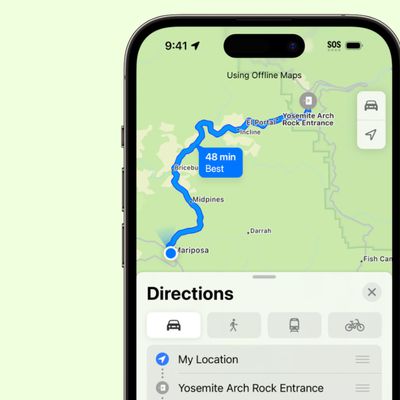
In iOS 17, Apple has added the ability to download Maps for use offline, providing access to turn-by-turn directions and information for a chosen area even if you do not have a cellular or Wi-Fi connection. Keep reading to learn how it's done. Apple Maps is catching up with Google Maps in iOS 17 by finally letting iPhone users download maps for offline use. Thanks to the new feature, you...
Read Full Article
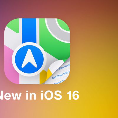
iOS 16: How to Use Multi-Stop Routing in Maps
In iOS 16, Apple Maps has received an update that brings multi-stop routing to the navigation app. Keep reading to learn how to use it. With iOS 16, the Maps app allows you to plan a route that has multiple stops instead of just a single destination. While Google Maps has had this feature for some time, this is the first version of Apple's Maps app to include support for it. When entering ...
How to Get a List of Directions in Apple Maps
After several years of iterations and improvements, Apple Maps has become a solid app and a viable Google Maps alternative for getting GPS-based directions to navigate journeys by car, public transport, bicycle, and on foot. Depending on the journey though, you may want to print off a list of turn-by-turn directions to refer to instead of relying on your iPhone and draining the battery. Or...
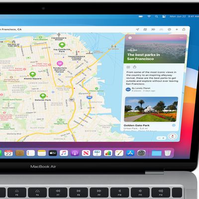
iOS 15: How to Find Fun Things to Do With the Dedicated Apple Maps Guide Section
In iOS 15, has brought several major improvements to the Maps app, with better driving directions, improved transit directions, and more immersive AR-based walking directions. In addition, Apple has added a dedicated Guides Home that houses editorially curated guides with tips on what to do in a city where you live or where you're visiting. To explore Apple's guides at any time in the...
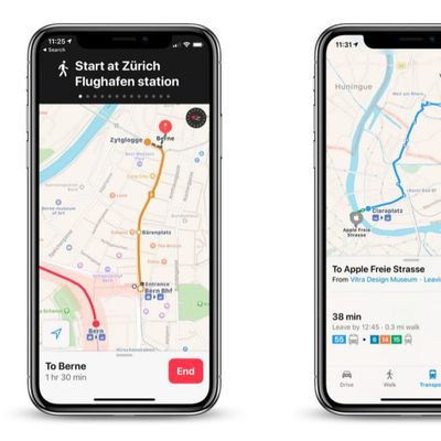
iOS 15: How to Find Transit Stations Near You in Apple Maps
In iOS 15, Apple's Maps app benefits from a range of new features and improvements, including the ability get real-time information on the nearby transit options available to you. This transit information can be found for major bus routes and rail lines in cities with updated maps. Transit riders can see all of the departures listed near them, including any existing delays on services, and...
iOS 15: How to Get AR Walking Directions in Maps
In iOS 15, Apple's Maps app benefits from a range of new features and improvements, including the ability to use augmented reality walking directions in big cities. In a nod to Google Maps, the new AR mode can map walking directions onto the real world by using your iPhone's rear camera, making it easier to see where you need to go in built-up areas and reducing the need to look down at your ...
iOS 15: How to Find User Settings in Maps
In iOS 15, Apple has added a user account area in the Maps app that corrals several custom areas like direction mode, toll and highway avoidance options, transit options, and more. To access it, simply tap the circular icon to the immediately to the right of the search bar. You should see your initials within the circle, indicating it's your account. A new menu card will pop up with...
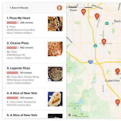
iOS 15: How to Filter Search Results in Maps
In iOS 15, Apple has worked to improve the search results in its Maps app, and has added the ability to filter results by options like what specific cuisine you're looking for, whether a restaurant is open or offers takeout, and more. In the following steps, we've demonstrated how it works by looking for restaurants that serve a particular type of cuisine, but you can filter other...
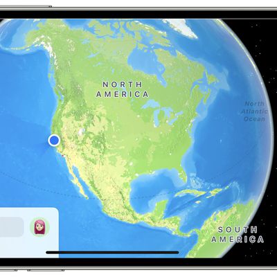
iOS 15: How to Use the Interactive Maps Globe
In iOS 15, Apple has enhanced the Maps app to include a new globe view that allows you to spin the world around and zoom into different regions on Earth. In previous versions of iOS, zooming out maximally in Maps would present you with a flat world map, but the new globe view gives you a three-dimensional view of Earth from space that's a lot more fun to navigate. It's easier, too –...
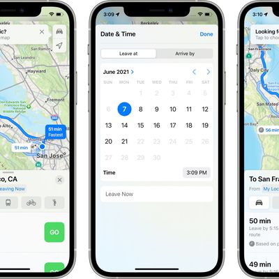
iOS 15: How to Set Leaving and Arrival Times for Driving Directions in Apple Maps
Apple Maps received several notable improvements in iOS 15, including new details in cities, an interactive globe, and enhanced driving directions. It also gained a feature that has long been available in rival map apps – the ability to set leaving and arrival times for driving directions. This is a feature that's long been available for Google Maps, and one that's really useful if you...

iOS 14.5: How to Report Speed Checks, Traffic Accidents, and Other Hazards in Apple Maps
In iOS 14.5 and later, Apple has added a Waze-like feature to its native Maps app that lets you report accidents, hazards, and speed checks along your route when getting directions. Keep reading to learn how it works. Driving on public roads can throw up all sorts of hazards, but if you're given prior warning then you can be better prepared to deal with them. Apple recognizes this, which is...
How to Clear Your Location History in Apple Maps
When you search a location in Apple Maps on iOS and Mac, the app conveniently remembers your search in case you want to return to it at a later time. However whether for housekeeping or privacy reasons, you can quickly and easily remove your Maps search history at any time. Keep reading to learn how its done. Delete Apple Maps History on iPhone and iPad Launch Apple's Maps app on your...
iOS 14: How to Use Guides in Apple Maps
In iOS 14, Apple's Maps app got a handful of new features and refinements, one of which is the ability to explore places with the help of Guides. Guides provide recommendations for the best places to visit in a city, offering up suggestions on places to eat, shop, and explore. Some of Apple's partners for these Guides include Lonely Planet, the Washington Post, AllTrails, The Infatuation, and ...
iOS 14: How to Get Cycling Directions in Apple Maps
Google Maps has featured detailed cycling directions for almost a decade now, and with the arrival of iOS 14, Apple Maps is finally introducing its own. The steps below show you how to make use of the new cycling directions in Apple's Maps app. If you have an Apple Watch running watchOS 7 or later, you can receive the directions you select right on your wrist, for easy at-a-glance navigation. ...

How to Ask Siri to Share Your ETA When Navigating With Apple Maps
In iOS 14, Apple has greatly expanded the number of direct answers Siri can give you. The majority of these answers are thanks to enhanced web-based information, but some of it is also down to Siri's tighter integration with other Apple apps. For example, the Apple Maps app lets you share your estimated time of arrival when you're following turn-based driving directions, and now you can ask ...
How to Share Your Estimated Time of Arrival in Apple Maps
In the latest version of Apple Maps that comes with iOS 13, Apple has added a Share ETA feature that lets you share your estimated time of arrival at a location with a friend or family member, allowing them to follow your progress in real-time for the duration of the trip. The following steps explain how to use the Share ETA feature in Apple Maps on iPhone and iPad. Note that Apple nixed the...
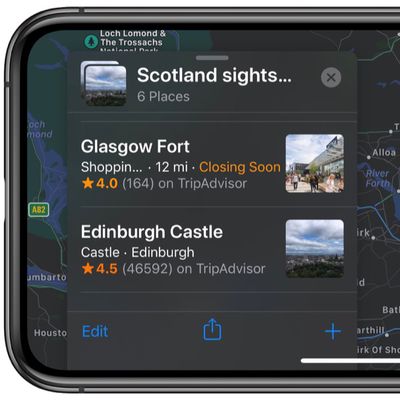
How to Create a Collection in Apple Maps
In iOS 13, Apple added a Collections feature to its Maps app on iPhone and iPad that lets you search for and aggregate lists of different locations, such as restaurants you're thinking of eating out at, sightseeing locations for when you're on vacation, or other places you want to visit. Collection lists can also be shared, so you can create lists of places for friends and family that will...
How to Send Feedback About Errors in Apple Maps
In iOS 13, Apple introduced a redesigned customer feedback process for its Apple Maps app which is designed to make it easier for users to submit corrections for things like incorrect addresses, business locations, or operating hours. If you find an error or something that needs updating in Apple's maps information, you can now send the correct details in just a few quick taps. The following...
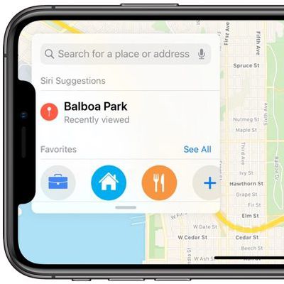
How to Add Places to Your Favorites in Apple Maps
In the latest version of Apple Maps that comes with iOS 13, Apple has added a Favorites feature that lets you search for specific places and then add them to a list. Favorites are meant for places that you visit frequently, and Home and Work are already added by default. Any place you frequent can be added to the Favorites list, such as a favorite restaurant or coffee shop, or a friend or...
How to Use Look Around in Apple Maps
With iOS 13, Apple introduced several additional features to its Maps app, one of which is called Look Around. This gives you a street-level view of what's around your current location or the location you search for on the map. If you've ever used Google Street View, you already have a good idea of how Look Around works, but Apple's equivalent feature includes a couple of functions that...
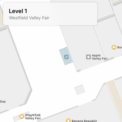
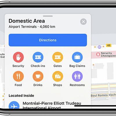
What's New in Maps in iOS 11: Indoor Mapping, Lane Guidance and Speed Limits
The Maps app in iOS 11 is outfitted with several new features that significantly improve the app's functionality. Indoor maps let you find restaurants, bathrooms, and other locations in airports and malls, while other new features like speed limits and lane guidance improve turn-by-turn directions. Fun fact: In iOS 11, Apple has also updated the Maps icon. The new version is meant to show off...
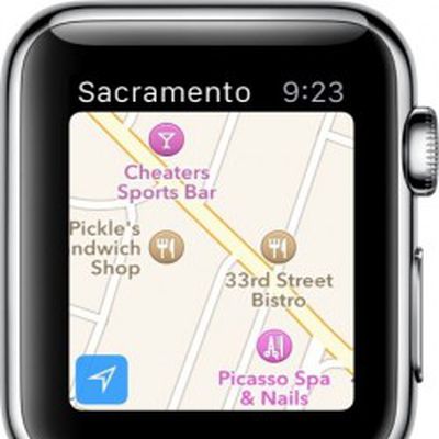
How to Use Apple Watch to Get Directions
Apple Watch includes a miniature version of Apple Maps, which offers many of the same features as the full iOS version if you know how to access them. Some of what Maps can do is fairly obvious, but there are a few features that require a bit more know-how. If you are interested in learning the ins and outs of Apple Maps on Watch OS and would like to know some simple tips for getting the most...
Apple Maps Guides
Apple Maps: Complete Guide to iOS 13
Apple introduced updates to many of the built-in iOS apps in iOS 13, and Maps is no exception. The updated version of Maps has a long list of new features that are designed to make the Apple Maps app better able to compete with mapping apps from other companies. There's a new Look Around street view level feature, a Collections feature for aggregating lists of your favorite places, a...
Apple Maps Articles

Apple Maps in iOS 13: Collections, Favorites, Look Around, and More
There are quite a few changes coming to the Maps app in iOS 13, which gives Apple Maps a feature set that more closely mirrors some of the tools and functionality available in more robust mapping apps like Google Maps. The most interesting and notable change in Maps is the new Look Around feature, which is Apple's answer to Google's Street View function. Look Around lets you get a street level ...

Apple Maps Vehicles Begin Surveying Canada
Apple today announced that its Apple Maps vehicles are now surveying Canada for the first time over the summer months. Apple Maps vehicle on Renforth Drive in Toronto via Reddit user whatifyoutry The vehicles will drive across all 10 provinces between May and November, including British Columbia, Alberta, Saskatchewan, Manitoba, Ontario, Québec, New Brunswick, Nova Scotia, Newfoundland and ...
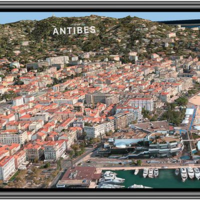
Apple Maps Gains Detailed Terrain Features for Arizona, New Mexico, and Nevada US States
As part of its ongoing effort to rebuild Apple Maps, Apple has added detailed terrain features to the U.S. states of Arizona and New Mexico as well as the southern portion of Nevada, including the city of Las Vegas. The enhancements are the result of Apple's street-level data collection using LiDAR-equipped vehicles, which has been going on for over three years. Related improvements first...
Apple Maps Vehicles to Begin Surveying Final U.S. States
As part of its efforts to rebuild Apple Maps, Apple has been collecting street-level data with LiDAR-equipped vehicles for over three years, with at least 45 states across the U.S. partially surveyed to date. That total is set to rise in the coming months, as Apple has confirmed it will begin surveying Alaska, South Carolina, and Tennessee between March and July, according to an update to...

New Report Delves Into Poor Working Conditions at an Apple Maps 'Black Site'
A new report out today by Bloomberg offers a look inside one of Apple's so-called "black sites," this one a satellite office near Apple Park in California where the company hires contractors to work on Apple Maps. These contract workers were hired by Apex Systems, which staffs and manages a few Apple mapping offices, and creates a "culture of fear" according to former employees. One former...
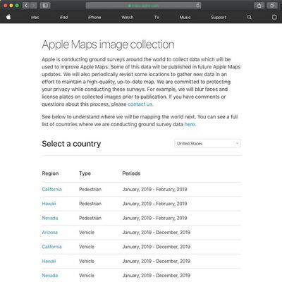
Apple Maps Launches Revamped Data Collection Website
As part of its efforts to rebuild Apple Maps "from the ground up," Apple has been collecting street-level data with LiDAR-equipped vehicles for over three years. Apple also deployed employees wearing LiDAR-equipped backpacks to collect pedestrian-based data starting in California late last year. As these efforts expand around the world, Apple recently transitioned to a revamped Apple Maps...
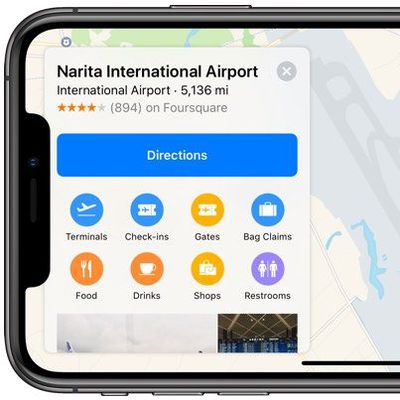
Apple Expands Transit Directions to New Areas, Introduces More Indoor Maps for Malls and Airports
Transit directions for Apple Maps have recently expanded to encompass the entirety of multiple states and countries, Apple today confirmed in an update to its Feature Availability page. Transit directions are now available across all of Alaska, Connecticut, Delaware, Florida, Georgia, Indiana, Illinois, Kentucky, Mississippi, Missouri, New Jersey, North Dakota, New York, Oklahoma, Rhode...
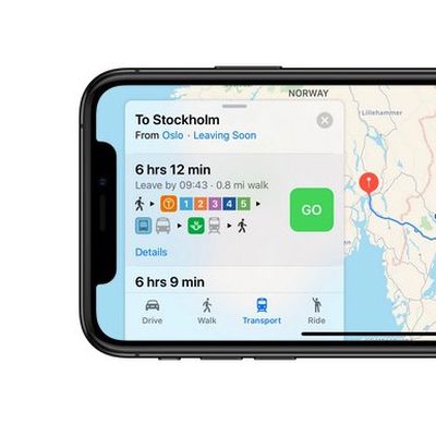
Apple Maps Gains Transit Directions for Denmark, Sweden, Norway, and Finland
Apple Maps today gained comprehensive transit directions for Denmark, Sweden, Norway and Finland, in the largest single combined update to its European coverage thus far. The coverage includes train, tram, and bus routes in the capital cities of each country, including Oslo, Stockholm, Copenhagen, and Helsinki, as well as funicular connections where available and transit links across...
DuckDuckGo Integrates Apple Maps for Map and Address Searches
Privacy-focused search engine DuckDuckGo today announced that it is using Apple's MapKit JS framework to power the map and address-related searches that its users conduct on both mobile and desktop. MapKit JS allows DuckDuckGo to provide users with improved address searches, new visual features, enhanced satellite imagery, and continually updated maps without sacrificing privacy....
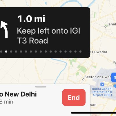
Apple Maps Gains Turn-by-Turn Directions for India
Apple has added turn-by-turn navigation to Apple Maps for India. The app now offers the detailed directions for driving and walking, with options to book a ride through Uber and Ola also showing within the app. Still missing for users in India is public transit information, lane guidance and speed limits, although given that the addition of turn-by-turn directions is part of an ongoing...
Apple Maps Gains New Indoor Mall Maps and Flyover Locations
According to its Feature Availability page, Apple today introduced a number of new features for Apple Maps. Several new Flyover locations have been added, and available maps for indoor malls have expanded. In some of these locations, the updates may have actually rolled out a few months ago, but Apple's updated list lets us know exactly where Maps feature are available. In other areas, the...
Apple Expands Transit Directions to New Locales and Introduces Indoor Maps at Additional Airports
Transit directions for Apple Maps have recently expanded to Belgium, Manila in the Philippines, Switzerland, Wyoming, and Iowa, Apple confirmed today in an update to its Feature Availability page for iOS. In these locations, Apple Maps users can get directions using the transit options available in their states or countries. Apple actually implemented transit directions in these locales over...
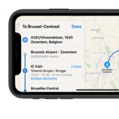
Apple Maps Now Provides Transit Directions Across Belgium
Following yesterday's Apple Pay launch in Belgium, Apple today updated its Maps app to include transit information across the country. Apple has yet to update its official list of locations for which Maps offers Transit data, but several tipsters contacted MacRumors to confirm the information is already live. The coverage includes train, tram, and bus routes in the main cities as well...

Apple Maps Collecting Pedestrian Data Starting in California, Likely to Improve Walking Directions
Last month, a person wearing an Apple Maps backpack with LiDAR equipment was spotted at the intersection of Stockton and Sutter streets in San Francisco, suggesting Apple now has employees collecting street-level data on foot. Apple Maps employee with a LiDAR-equipped backpack via Dante Cesa Apple has since confirmed that its Maps team will be collecting pedestrian data in California over...
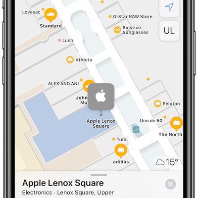
Apple Maps Gains Indoor Maps at Over 20 Additional Shopping Malls and Airports Around the World
Apple Maps has added indoor maps at over 20 additional shopping malls and airports across the United States, Singapore, Hong Kong, and Denmark. Newly supported locations:Lenox Square in the Atlanta, GA Phipps Plaza in the Atlanta, GA Perimeter Mall in Atlanta, GA Cumberland Mall in Atlanta, GA North Point Mall in Alpharetta, GA Mall of Georgia in Buford, GA The Shoppes at River...
Apple Maps Now Provides Transit Directions Across Switzerland
Apple has updated its Maps app to include transit information for Switzerland, including indoor maps for the country's busiest airport in Zurich. Apple has yet to update its official list of locations for which Maps offers Transit data, but several tipsters contacted MacRumors to confirm the information is already live. Switzerland is renowned for its integrated country-wide transport...

Man Wearing Apple Maps Backpack Surveying San Francisco on Foot
Apple is expanding its street mapping efforts beyond vans outfitted with LIDAR equipment and now has employees collecting street level data on foot. MacRumors reader Dante Cesa spotted a man wearing an Apple Maps backpack featuring a LIDAR rig, GPS, and multiple cameras, some of the same equipment that's previously been spotted on Apple's mapping vans. Apple has been collecting...

New Apple Maps Cars Spotted in Los Angeles
New next-generation Apple Maps vehicles have been seen on the streets of Los Angeles, according to Business Insider. While Apple has previously been using minivans to collect mapping data, the new vehicles are Subaru Impreza wagons. The Subarus feature new LIDAR equipment that we have not previously seen either on Apple's Maps minivans or on the Lexus SUVs that it is using to test self-driving ...
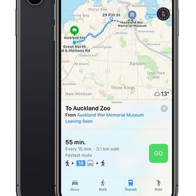
Apple Maps Now Provides Transit Directions Across New Zealand
Apple Maps now supports transit in New Zealand, enabling users to navigate with public transportation in most populated areas of the country. In the largest city of Auckland, directions are available for NZ Bus routes, AT Metro trains, or the SkyBus shuttle to the Auckland Airport. In the capital area of Wellington, directions are available for Metlink buses and trains. Between select...
Apple Maps Transit Directions Rolling Out in Alaska, Wyoming and Idaho
Apple recently updated its Maps app to add transit directions and data for areas in Alaska, Wyoming, and Idaho. Apple Maps users in select cities in these states can now select public transportation routes when getting directions between two locations. In Alaska, for example, there are bus routes and other transit options in cities that include Anchorage, Juneau, and Fairbanks. In...