Google Maps
By MacRumors Staff
Google Maps How Tos

How to Clear Google Maps Search History on iPhone and iPad
If you prefer using Google Maps over Apple Maps on your iPhone or iPad, it's useful to know that you have the ability to manage how long your map search history is stored on Google's servers. This article shows you how.
When you start typing the name of somewhere in Google Maps, the app throws up suggestions of your recent searches for places and directions, which can be useful if you visit...
Read Full Article
Google Maps Articles
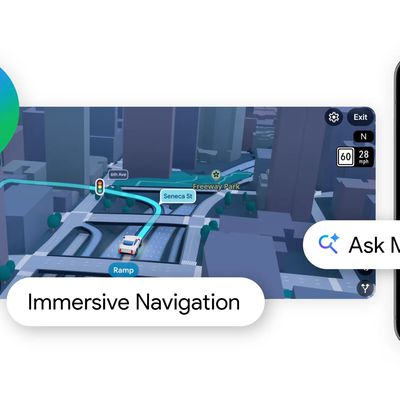
Google Maps Adds Gemini AI-Powered 'Ask Maps' Feature and 3D Immersive Navigation
Google today added Gemini AI to Google Maps, enabling a new Ask Maps feature. Gemini in maps can answer complex, real-world questions that Google says "a map could never answer before."
There is a new Ask Maps button where Google Maps users can get answers to specific questions like "is there a public tennis court with lights on that I can play at tonight?" Google says that finding...
Google Maps Now Lets You Chat With Gemini AI While Walking or Biking
Google Maps now lets you talk to Gemini while following walking or cycling directions. The latest update is an extension to the AI chatbot's existing conversational navigation feature in driving mode that rolled out in November.
You can now ask Gemini hands-free questions without leaving the navigation screen. While walking, for example, you can ask things like "Tell me more about this...

Google Maps Quietly Added This Long-Overdue Feature for Drivers
Google Maps on iOS quietly gained a new feature recently that automatically recognizes where you've parked your vehicle and saves the location for you.
Announced on LinkedIn by Rio Akasaka, Google Maps' senior product manager, the new feature auto-detects your parked location even if you don't use the parking pin function, saves it for up to 48 hours, and then automatically removes it once...
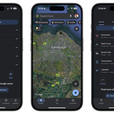
Google Maps Getting Gemini AI Tips, EV Charger Predictions, and Anonymous Reviews
Google today announced several new features that are coming to the Google Maps app, including Gemini-powered tips, trending places, and estimates on EV charger availability.
When searching for places in the Google Maps app like restaurants or hotels, there's now a "Know Before You Go" section that's powered by Gemini. The section provides tips on what to expect, pulling information from user ...
Google Maps Unveils 4 Major Updates for European Commuters
Google has announced four Maps updates across Europe designed to reduce reliance on driving and promote sustainable transportation choices.
Google says it's expanding its AI-powered alternative transport suggestions to Copenhagen, Stockholm, Warsaw, and additional cities in the coming months. The feature predicts when walking or transit will match driving times, which aims to help users...
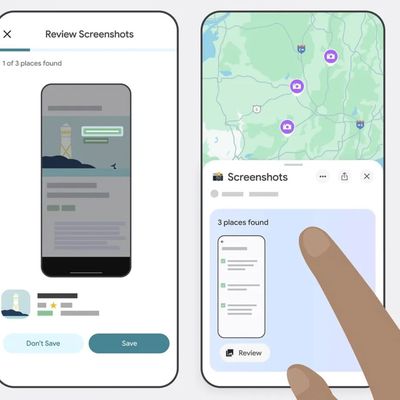
Google Maps Can Now Scan Your iPhone Screenshots for Places
Google Maps has gained the optional ability to scan screenshots in your iPhone's photos and save any found locations to a dedicated list.
Powered by the company's Gemini AI, the new feature lets Google Maps search for any screenshots in your photos, such as social media posts, news articles, and travel blogs, and capture them in the app under a new Screenshots List under the You tab.
The...
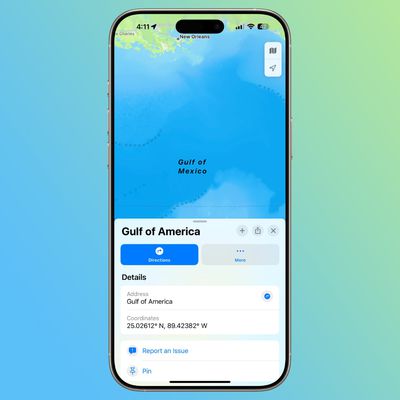
Apple Adopting 'Gulf of America' Naming for Apple Maps
Apple is in the process of renaming the Gulf of Mexico to the Gulf of America, and changes are already being made to the Apple Maps app. When searching in the Maps app for Gulf of Mexico, the Gulf of Mexico name is shown or the name is blank, but tapping into the area shows the "Gulf of America" wording.
According to Bloomberg, Apple is rolling out the Maps change in the United States today, ...
iOS 18.4 to Let EU Users Set Google Maps as Default Navigation App
With the release of iOS 18.4 in the spring, Apple's mobile operating system will likely let iPhone users in the European Union set default navigation and translation apps for the first time.
In iOS 18.2, Apple introduced a way for users to select their preferred default apps for iPhone. Apple initially promised that the feature would be coming to the EU, but it is actually available...

Google Maps Can Now Help You Find Last-Minute Holiday Gifts
Google Maps has been given a fairly substantial update in time for the holidays, with the introduction of an in-app product search function to help users find specific items at nearby stores. The new feature allows shoppers to search for electronics, home goods, grocery items, and last-minute gifts directly within the Maps interface.
The update also brings navigation enhancements, with...
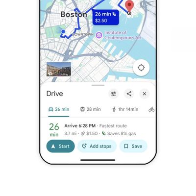
Google Maps Rolling Out These New Navigation Features This Week
Google Maps is rolling out several new features to iOS and Android users this week, focusing on improved navigation and travel planning tools.
A new prominent "Add stops" button is being added alongside the Start button with the idea of simplifying route planning: It displays restaurants, gas stations, and points of interest along the way. This week's update also introduces weather...
Google Maps Loses Two Tabs Out of Five in Bottom Bar Redesign
Google Maps is rolling out a redesigned bottom bar to iPhones that aims to give the app a less cluttered look by reducing the number of tabs on the screen.
Old Google Maps bottom bar (left) vs. new one
Previously only on Android, the new bottom bar reduces the number of tabs from five to three. As spotted by 9to5Google, "Go" has been removed, but users can still access it using a new "You"...
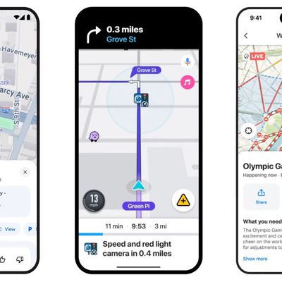
Google Maps and Waze Updated With New iPhone and CarPlay Features
Google has announced new Waze and Google Maps features rolling out for iPhone and CarPlay users that aim to keep them safer and more informed on the go.
First up, changes to Maps aim to make it easier to report incidents and helpful information, like nearby construction, lane closures, objects and police presence. These reports come from the Maps and Waze communities, and users will now see ...
Google Maps for iOS and Apple CarPlay Gains Live Speedometer Feature
The Google Maps app for iOS and Apple CarPlay now features a live speedometer, TechCrunch reports.
The feature, which was previously only available on Google Maps for Android, helps users to stay within the speed limit while driving. Now, when a user begins navigation, the vehicle's speed is shown in miles or kilometers per hour, depending on the region. The icon changes color depending on...
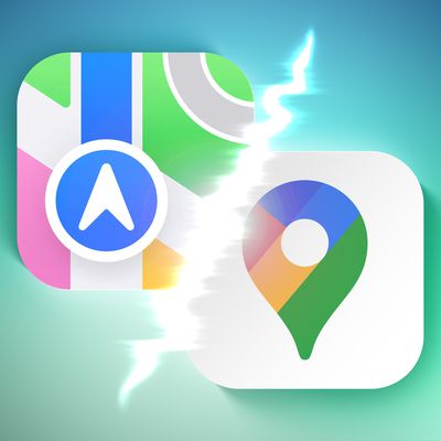
Apple Maps vs. Google Maps: Which Is Better?
Apple Maps has been providing navigational guidance to Apple users for almost 13 and a half years now, and much has changed about the app in that time. However, according to data from Canalys, the overwhelming majority of iPhones in the U.S. still have Google Maps downloaded as an alternative to Apple Maps, which comes preinstalled on all iPhones. We want to hear from MacRumors readers. Which...
Google Maps Finally Rolls Out Glanceable Directions
After more than a year since announcing the feature, Google Maps is finally rolling out glanceable directions on Android and iOS (via Android Police).
The feature allows users to view turn-by-turn directions and a live ETA directly from their device's lock screen – information that was previously only visible when a phone was unlocked.
Glanceable directions also work on the app's route...

Google Maps Still Working On Long-Overdue Live Activities Support
Google Maps continues to work on integrating Live Activities support for iPhones, according to new assets unearthed by MacRumors contributor Aaron Perris in the latest version of the app.
Evidence that the feature was in development first appeared in August, but further work on it had appeared to have come to a standstill until now, suggesting it could become functional soon.
The Google...
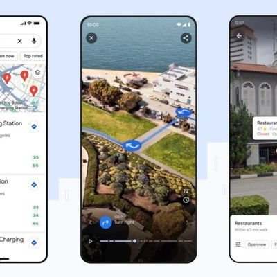
Google Maps Gains Immersive View for Routes and Other AI Features
Google Maps is getting a new Immersive View for routes that uses artificial intelligence, Street View, and aerial images to preview every step of a journey ahead of time.
When users get directions for driving, walking, or cycling, Google Maps now offers a "multidimensional experience" that can be used to preview bike lanes, sidewalks, intersections, and parking along the route, according to...
Google Maps Preparing Live Activities Support Ahead of Dynamic Island Expanding to All iPhone 15 Models
The latest version of the Google Maps app for the iPhone includes hidden code-level references to Live Activities, according to MacRumors contributor Steve Moser. The feature remains in development and it is not yet functional in the app.
Live Activities will allow Google Maps users to view turn-by-turn directions and the ETA in a single live-updating Lock Screen notification, and in the...

Google Maps to Offer Turn-by-Turn Directions in iPhone's Dynamic Island
Google today announced that its Maps app will support Live Activities in the coming months, providing iPhone users with access to turn-by-turn directions on the Lock Screen and in the Dynamic Island on the iPhone 14 Pro and iPhone 14 Pro Max.
Live Activities integration will allow users to receive real-time ETAs and directions for driving, biking, walking, public transit, and other forms of...
Google Maps for iOS Gaining Augmented Reality Live View Search in Select Cities
Google is bringing a new augmented reality Live View feature to its Maps app, allowing smartphone users to visually search for restaurants, coffee shops, and other businesses that are located nearby.
Using Live View, you can open up Maps and tap the camera icon in the search bar to see what's around you, from shops and banks to ATMs and bars. Google Maps will provide AR-powered directions...