Google Maps Gains Enhanced Street-Level Detail in Four Major Cities
Google Maps has quietly been updated to include significantly more detailed street-level information in a handful of key cities around the world.
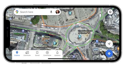
Upon zooming in, Google's maps for Central London, Tokyo, San Francisco, and New York now benefit from shapes and widths that match the scale of roads more accurately.
Meanwhile, enhanced graphical representations of sidewalks, crosswalks, pedestrian islands, and street-side flora have also been added, which should help users who rely on the maps for walking directions.
Lastly, parks now show the actual width of pathways in dark green along with any stairs in grey, offering improved accessibility information for wheelchair users or people with a stroller.
Some of the improvements are undoubtedly subtle, but underline Google's commitment to improving city-wide coverage. The changes are server-side and therefore require no software update, and Google says it plans to expand the new details to additional cities in the future.
Google Maps can be downloaded from the App Store for free. [Direct Link]
(Via AndroidPolice.)
Popular Stories
Apple recently added the iPhone 16e to its refurbished store, with U.S. pricing starting as low as $419 for a model with 128GB of storage.
Originally released in February 2025, the iPhone 16e is a lower-end device with a 6.1-inch OLED display, an A18 chip with 8GB of RAM for Apple Intelligence support, a single 48-megapixel rear camera, a 12-megapixel front camera, a USB-C port, an Action...
New Chinese regulatory certification filings appear to confirm the battery capacities of Apple's upcoming iPhone 18 Pro and iPhone 18 Pro Max models.
According to new filings in China's C3 database, spotted by the leaker known as "Digital Chat Station" on Weibo, the iPhone 18 Pro is seemingly rated for 4,056mAh in China and 4,288mAh in the U.S., up modestly from the iPhone 17 Pro's 3,988mAh...
Using Apple Intelligence camera features in the Home app will require an iCloud+ plan starting at 2TB, according to Apple. Apple shared the detail in its notes for the third macOS Golden Gate beta that was released today.
In iOS 27, iPadOS 27, and macOS 27 Golden Gate, the Home app is able to generate written summaries for motion alerts from HomeKit Secure Video cameras. It's also able to...