Revamped Apple Maps App Expanding to UK, Ireland, and Canada Later This Year
Apple today announced its revamped Maps app will be expanding to the United Kingdom, Ireland, and Canada later this year.
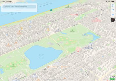
The updated Maps interface features richer landscape details such as roads, parking lots, parks, buildings, airports, and more. To obtain its mapping data, Apple utilizes its own vehicles equipped with LiDAR sensors and cameras.
Apple had been working for over a year to complete the rollout of the new Maps app in United States, which concluded in January with the expansion of Southeast and Central United States.
Aside from this, Apple in iOS 14 is adding guides to places of interest, dedicated cycle routes, and more to the Maps app.
Popular Stories
Apple's WWDC 2026 graphic provides "a glimpse of the revamped Siri interface coming in iOS 27," according to Bloomberg's Mark Gurman.
In his Power On newsletter today, Gurman said iOS 27 will include a new Siri interface in the Dynamic Island. When you trigger Siri, he said the Dynamic Island will show a "Search or Ask" prompt, and this will apparently be accompanied by a "glowing cursor"...
Apple today highlighted four Distinguished Winners of this year's Swift Student Challenge, ahead of the WWDC 2026 developers conference next month.
The annual Swift Student Challenge gives eligible student developers around the world the opportunity to showcase their coding capabilities by using the Swift Playground or Xcode apps to create an interactive "app playground."
Apple said this...
macOS 27 will have a "slight redesign" compared to macOS Tahoe, according to the latest word from Bloomberg's Mark Gurman.
In his Power On newsletter today, Gurman said the design changes will help to improve the readability of macOS Tahoe's Liquid Glass interface:If you've used Tahoe, you're likely familiar with some of the quirks — particularly the transparency effects and shadows that...