Google Maps Expands 'Parking Difficulty' Indicator to 25 Cities Around the World - MacRumors
Skip to Content

Google Maps Expands 'Parking Difficulty' Indicator to 25 Cities Around the World

by

Google today announced its "parking difficulty" indicator in Google Maps for iOS and Android will now appear in 25 additional cities around the world. The feature was previously available in the United States only.

google maps parking difficulty
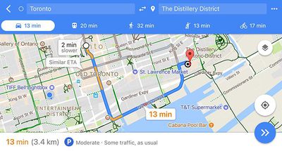
The simple feature shows a "P" icon with a difficulty level such as "moderate" or "limited," based on how easy it will be to find parking at the destination entered. The feature is based on historical parking data and machine learning.

The following cities support the feature starting today:

  • Alicante

  • Amsterdam

  • Copenhagen

  • Barcelona

  • Cologne

  • Darmstadt

  • Düsseldorf

  • London

  • Madrid

  • Málaga

  • Manchester

  • Milan

  • Montréal
  • Moscow

  • Munich

  • Paris

  • Prague

  • Rio de Janeiro

  • Rome

  • São Paulo

  • Stockholm

  • Stuttgart

  • Toronto

  • Valencia

  • Vancouver

Google Maps is available for free on the App Store [Direct Link] for iPhone and iPad.

Top Rated Comments

one more Avatar
115 months ago
I just need apple to get driving directions accurate and smart and cover all major markets for public transportation.
And this is exactly the area where they still fail spectacularly. No public transportation in an international hub of Geneva, Switzerland (Google had it for years) and plain wrong old road layout 10 miles away from it in France, despite five (!) error reports from me for the same spot over the last year (!). Waze & Google, meantime, both have it spot on and Waze had it right first, within weeks. So I use Waze for driving and glance at Apple Maps from time to time hoping they would have caught up.
Score: 1 Votes (Like | Disagree)
baryon Avatar
115 months ago
This can be pretty useful. I never know how much time I'll have to spend circling around streets to find an empty parking spot. Sometimes there are many empty spots, sometimes I have to give up after 40 minutes of unsuccessful searching and just go somewhere else. It's different for every part of town, at every time of day, and I don't know them all by heart. Though, it can easily be estimated from traffic. If there's heavy traffic, you bet the parking spots are all taken.

What I wish they included is the price of parking at each time of day. This is readily available online and would be super handy to have directly in Google maps. "If you park here, it will cost this much per hour until 18:00 and you can't stay for more than 3 hours." that would save a lot of Googling each time.

Oh and how about a way to pay for your parking ticket from Google maps? Automatic zone recognition, time calculation, etc... There are some apps to do it but they take a bounty. I bet Google could beat them.
Score: 1 Votes (Like | Disagree)

Popular Stories

Apple Event Logo

Apple to Release These 15 New Products Later This Year

Friday June 12, 2026 7:45 am PDT by
Apple's annual WWDC developers conference is drawing to a close, but there is still a lot to look forward to in the second half of the year. Apple is expected to release at least 15 more products later this year. Now that the more intelligent and personal version of Siri has finally arrived in beta, a full two years after Apple first previewed it at WWDC 2024, we should begin to see some new ...
Apple Lists 250 Changes Across iOS 27 and More Feature

Apple Shares List of 250 Changes Across iOS 27, macOS Golden Gate, and More

Wednesday June 10, 2026 1:34 pm PDT by
During its WWDC 2026 keynote on Monday, Apple briefly showed a slide with hundreds of new features and enhancements coming across iOS 27, macOS 27 Golden Gate, watchOS 27, tvOS 27, and visionOS 27. All of the software updates are currently available as developer betas, and they are expected to be released to all users in September. We already highlighted some of the key new features from the ...
liquid glass app icon

Apple Maps to Get These 10 New Features in iOS 27

Thursday June 11, 2026 5:45 am PDT by
Apple Maps is getting a range of new features in iOS 27, headlined by an upgraded Flyover experience that uses AI to improve the realism and detail of its aerial imagery. Flyover is a longstanding feature of Apple Maps and lets users explore more than 350 cities in 3D with detailed landmarks, roads, parks, and buildings. Apple described the enhanced Flyover in iOS 27 as combining aerial...