Skip to Content

Google Maps to Gain New 'Live View' AR Features

Live View in Google Maps uses your iPhone's camera and GPS to provide augmented reality directions when you're walking somewhere, and this week Google announced that it's enhancing the feature and making it available in additional transit scenarios.

Screen Shot 1
In Live View, arrows, directions, and distance markers are placed right on top of your surroundings to visualize your destination in the real world, and Google will soon bring landmarks to this AR mode, too. From The Keyword blog:

Soon, you’ll also be able to see nearby landmarks so you can quickly and easily orient yourself and understand your surroundings. Live View will show you how far away certain landmarks are from you and what direction you need to go to get there. These landmarks can include iconic places, like the Empire State Building in New York and the Pantheon in Rome, and easily recognizable places, like local parks and tourist attractions.

Landmarks will start rolling out soon on iOS in nearly 25 cities, including Amsterdam, Bangkok, Barcelona, Berlin, Budapest, Dubai, Florence, Istanbul, Kuala Lumpur, Kyoto, London, Los Angeles, Madrid, Milan, Munich, New York, Osaka, Paris, Prague, Rome, San Francisco, Sydney, Tokyo, and Vienna.

Live View is accessed from the transit tab in Google Maps, but previously, it would be unavailable if your directions involved a combination of transport types like walking, driving, cycling, and transit.

Landmarks Live View
Now though, as long as your transit directions include a walking portion in the journey, you can use Live View to find your way, which should be useful when you exit a transit station and don’t know which way to go, for example.

In addition, Google said it will soon expand Live View to Location Sharing, so that when a friend chooses to share their location with you, you can tap their icon and then on Live View to see where and how far away they are, with overlaid arrows and directions to help you know where to go.

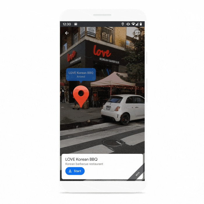
Google says it has made improvements to global localization, the underlying technology that powers its Live View features on Google Maps, so it's now better able to take the elevation of a place into account, which enables it to more accurately display the location of the destination pin in Live View.

Google Maps can be downloaded from the App Store for free. [Direct Link]

Popular Stories

iOS 27 Mock Quick

iOS 27 Will Reportedly Be Like Mac OS X Snow Leopard

Sunday March 15, 2026 9:42 am PDT by
In his Power On newsletter today, Bloomberg's Mark Gurman reiterated that iOS 27 will be similar to 2009's Mac OS X Snow Leopard, in the sense that one of Apple's biggest priorities is bug fixes for improved performance and stability. During WWDC 2008's State of the Union, Apple showed a slide that said Mac OS X Snow Leopard had "0 new features," as it opted to focus on performance and...
AirPods Max 2 Feature

Apple Announces AirPods Max 2 With H2 Chip and More

Monday March 16, 2026 6:12 am PDT by
Apple today unveiled AirPods Max 2, with key upgrades including the H2 chip, increased active noise cancellation, improved sound quality, and features such as Adaptive Audio, Conversation Awareness, Voice Isolation, and Live Translation. The new AirPods Max have the same overall design as the previous generation, with most of the new features coming from the upgrade to the H2 chip:- Adaptive ...
apple design award 2025

Apple Announces 2025 Design Award Winners Ahead of WWDC 2025

Tuesday June 3, 2025 10:14 am PDT by
As we wait for WWDC to kick off next Monday, Apple today announced the winners of its annual Apple Design Awards, recognizing apps and games for their innovation, ingenuity, and technical achievement. The 2025 Apple Design Award winners are listed below, with one app and one game selected per category: Delight and Fun - CapWords (App) and Balatro (Game) Innovation - Play (App) and PBJ -...

Top Rated Comments

71 months ago
Light years ahead of Apple Maps and available in most places across Europe. I guess I’ll be dead before “look around” is widely available, and I’m in my 30s... Shame on Apple!
Score: 5 Votes (Like | Disagree)
LFC2020 Avatar
71 months ago
Nice feature, can see battery life taking a massive hit while using it though.
Score: 3 Votes (Like | Disagree)
Morgenland Avatar
71 months ago

Nice feature, can see battery life taking a massive hit while using it though.
Probably also the data volume. If Google wants to collect new image environments in this way.
Score: 3 Votes (Like | Disagree)
one more Avatar
71 months ago
Visually, I prefer Apple Maps, but love seeing Google making significant advances and keeping Apple on their toes. ✌️
Score: 3 Votes (Like | Disagree)
LFC2020 Avatar
71 months ago

Apple Maps is getting Street View soon! :D
Don’t we already have that? Called look around.
Score: 2 Votes (Like | Disagree)
GeoStructural Avatar
71 months ago
Amazing. And to think someone here said tech companies would not do something unless Apple does it first.


Don’t we already have that? Called look around.
Yes, in a handful of cities.
Score: 2 Votes (Like | Disagree)