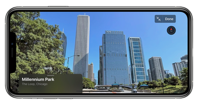
Apple this week has expanded its "Look Around" feature for Apple Maps to include Chicago, the latest major U.S. city to gain the 3D street-level imagery to compete with Google's Street View.
The expansion of Look Around to Chicago has been documented in detail by Justin O'Beirne, who notes that this brings the total number of metropolitan areas with Look Around to ten. The most recent expansion prior to this week came in February when Boston, Philadelphia, and Washington, D.C. were added.
As O'Beirne notes, while Look Around only covers 0.3 percent of the land area in the United States, it covers 13.8 percent of the U.S. population. That's still a far cry from Google's nearly ubiquitous Street View coverage, although Look Around has been compared favorably to Street View for the quality of its imagery and the smoothness of transitions as you navigate around.
In areas where Look Around is available, a binoculars icon will appear in the top-right corner of Apple Maps. Tapping that icon opens a street-level view in a card overlay at the top of the screen, which can then be expanded to a full-screen view. Look Around also appears in the search results for a supported city, below the Flyover and Directions buttons.
Apple is unsurprisingly prioritizing the largest cities in the U.S. with its Look Around feature in order to most efficiently cover the largest number of people, with O'Beirne noting that eight of the ten Look Around areas rank among the ten largest urban areas in the country. The two outliers, Las Vegas and Honolulu, are major tourist destinations and thus also prime targets for the feature.
O'Beirne has much more in his blog post on the expansion, including some predictions on which cities might be next to see Look Around.