Apple Maps now supports public transportation in several Tennessee metropolitan areas, including Nashville, Memphis, Knoxville, and Chattanooga.

apple maps transit nashville tennessee
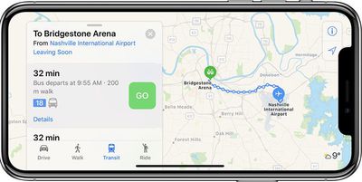
By selecting the Transit tab in Apple Maps on iPhone, iPad, Mac, or Apple Watch, commuters can navigate with bus routes, complete with arrival and departure times, service advisories, and other detailed information.

Transit agencies supported include MTA in Nashville, MATA in Memphis, KAT in Knoxville, CARTA in Chattanooga, and a few others in outlying areas.

Apple Maps has aggressively expanded its transit-supported cities over the past few months to include St. Louis, Missouri; Richmond, Virginia; Norfolk, Virginia; Tucson, Arizona; Albuquerque, New Mexico; Orlando, Florida; Toledo, Ohio; and Columbia, Charleston, and Greenville in South Carolina.

When the feature launched in 2015, it was initially limited to Baltimore, Berlin, Boston, Chicago, London, Los Angeles, Mexico City, New York, Philadelphia, San Francisco, Sydney, Toronto, and around 300 cities in China.

A complete list of supported cities can be found on Apple's iOS Feature Availability page. A reliable tipster recently informed MacRumors that Charlotte, Oklahoma City, Tulsa, Wichita, Indianapolis, Grand Rapids, Lansing, Brunswick, and Portland, Maine are candidates for the feature's continued rollout this month.

Top Rated Comments

redneckitengineer Avatar
67 months ago
Hey! This is awesome. Another win for Tennessee.
Score: 4 Votes (Like | Disagree)
cmmncw Avatar
67 months ago
I’ve been keeping a close tab on Apple’s transit directions roll-out, and their coverage in the United States is quite good now. Of the top 75 largest metropolitan areas in the U.S., Apple has transit directions in 57 of them now by my count (and most of the cities not covered are towards the bottom in terms of the population of the 75). Here are the metro areas missing in descending order by metro population:
-Charlotte, NC (they have orange station outlines, so it’s likely coming soon)
-Indianapolis, IN (ditto, orange station outlines)
-Jacksonville, FL (orange station outlines)
-Oklahoma City, OK (orange station outlines)
-Louisville, KY
-Raleigh, NC
-Buffalo, NY
-Rochester, NY
-Grand Rapids, MI
-Tulsa, OK
-Fresno, CA
-Bakersfield, CA
-Albany, NY
-McAllen, TX
-El Paso, TX
-Allentown, PA
-Baton Rouge, LA
-Greensboro, NC

They usually roll out directions in batches within states, so I expect a few upcoming batches (Charlotte, Raleigh & Greensboro in NC together, or OKC & Tulsa in OK together, or Buffalo & Rochester in NY, etc.) Their coverage in Europe, however, still isn’t very good.
Score: 4 Votes (Like | Disagree)
truthertech Avatar
67 months ago
It's long past time to stop referring to Apple Maps transit rollouts as "cities." They are doing entire regions and now have well thousands of cities covered with hundreds of millions of population around the world. It's also good to periodically remind people as to why Apple doesn't simply turn them on all at once which they could by simply importing the transit companies' data like Google did. Google received and continues to receive criticism about its transit directions, so Apple is customizing each region for more accuracy and user friendliness and integration with local and regional transits. Here's a great article that explains in detail why Apple's approach is better.

https://appleinsider.com/articles/16/07/07/why-apples-transit-maps-are-rolling-out-so-slowly
Score: 3 Votes (Like | Disagree)
Mad Mac Maniac Avatar
67 months ago
So how does *transit* specifically compare with google maps now? Both in functionality and coverage?
Score: 2 Votes (Like | Disagree)
tzm41 Avatar
67 months ago
It's long past time to stop referring to Apple Maps transit rollouts as "cities." They are doing entire regions and now have well thousands of cities covered with hundreds of millions of population around the world. It's also good to periodically remind people as to why Apple doesn't simply turn them on all at once which they could by simply importing the transit companies' data like Google did. Google received and continues to receive criticism about its transit directions, so Apple is customizing each region for more accuracy and user friendliness and integration with local and regional transits. Here's a great article that explains in detail why Apple's approach is better.

https://appleinsider.com/articles/16/07/07/why-apples-transit-maps-are-rolling-out-so-slowly
Question: if their approach is so slow in rolling out cities, would it also be super slow to update anything changed for any of the thousands of cities' transit system they support?
Score: 1 Votes (Like | Disagree)
Mad Mac Maniac Avatar
67 months ago
Question: if their approach is so slow in rolling out cities, would it also be super slow to update anything changed for any of the thousands of cities' transit system they support?
Hmm... interesting question. I could see it both ways. If there is a lot of manual work required for each new development then I would imagine it could take awhile, but if Apple has worked out some sort of data-share/integration with the transit systems, then maybe it would be pretty quick.
Score: 1 Votes (Like | Disagree)