
Apple Maps Expands Transit Data to Honolulu and Kansas City - MacRumors
Skip to Content

Apple Maps Expands Transit Data to Honolulu and Kansas City

by

Apple Maps has been updated with comprehensive transit data for the U.S. cities of Honolulu, Hawaii and Kansas City, Missouri, enabling iPhone users in the areas to navigate using public transportation, including buses and commuter rails.

Apple-Maps-Transit-Kansas-City
Transit routing options in the Kansas City metropolitan area include RideKC buses and the downtown KC Streetcar. Directions extend to most suburbs in both Kansas and Missouri, including Overland Park, Olathe, Independence, Lee's Summit, Shawnee, Blue Springs, Lenexa, and other smaller communities.

Transit routing options in Honolulu include TheBus buses, with directions extending to destinations across the entire Oahu island.
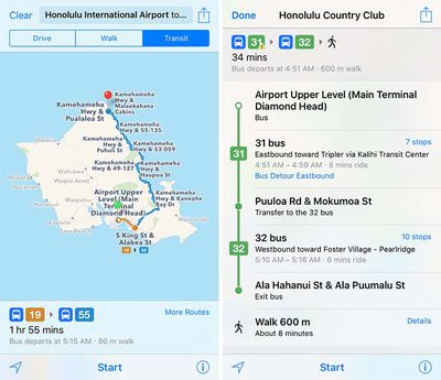
Apple-Maps-Transit-Honolulu
Apple introduced Transit in Maps as part of iOS 9 in select cities around the world, including Baltimore, Berlin, Boston, Chicago, London, Los Angeles, Mexico City, New York, Philadelphia, San Francisco, Sydney, Toronto, and 30 cities in China.

The feature has since expanded to a number of additional cities and regions around the world, including Atlanta, Denver, Miami, Montréal, Portland, Rio de Janeiro, Sacramento, Seattle, and New South Wales, Australia.

(Thanks, Ram!)
Top Rated Comments

heeloliver Avatar
132 months ago
Kansas City represent!
Score: 3 Votes (Like | Disagree)
truettray Avatar
132 months ago
Awesome. Now I can know how late our useless streetcar will be to pick me up to go nowhere.
Score: 2 Votes (Like | Disagree)
132 months ago
I find these transit updates to be WAY more useful than the flyovers. Hopefully they will focus more on transit. :)
Score: 1 Votes (Like | Disagree)
Gasu E. Avatar
132 months ago
All these little US Cities!! What about East Blobnigburg in the Republic of Crocknia?!!! Fess up, Apple, you hate Crocknians!
Score: 1 Votes (Like | Disagree)

Popular Stories

trump lake america

Apple Maps Renames Lake Ontario 'Lake America'

Tuesday September 1, 2026 1:58 pm PDT by
Apple Maps users in the United States will now see "Lake America" instead of "Lake Ontario" for the Great Lake on the border of Ontario and New York. The updated name is currently rolling out to iPhone, iPad, and Mac users. The Maps app still has the Lake Ontario label for the body of water, but tapping it now says "Lake America." Apple will likely change the label in the next few hours....
Apple Maps Google Maps Icons

Google Maps Showing 'Lake America' in U.S., Apple Maps Yet to Follow

Monday August 31, 2026 6:33 am PDT by
Google Maps users in the U.S. will now see the name "Lake America" instead of "Lake Ontario" for the Great Lake that straddles the New York—Ontario border. Google said it made this change in response to the U.S. Geographic Names Information System (GNIS) updating the name for "Lake Ontario" to "Lake America," following an executive order issued by U.S. President Donald Trump last week....
apple maps ads live

Apple Maps Ads Are Here, and There's No Way to Turn Them Off

Tuesday August 25, 2026 1:40 pm PDT by
Ads in Apple Maps are live in the United States and Canada, which means iPhone and iPad users will see them when searching for locations and when viewing Suggested Places. Apple announced plans to bring ads to the Maps app in March, and said the feature would roll out starting in late summer. Apple confirmed to 9to5Mac that ads began showing up for users over the last few days, with ad...