Ahead of the 2016 Worldwide Developers Conference, Apple's Maps team is working hard to expand transit directions to additional locations. Starting this morning, transit information in the United Kingdom has expanded to encompass the National Rail, which represents several public transportation systems across Great Britain.
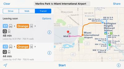
In the United States, transit directions are now available in Atlanta and Miami. In Atlanta, Metropolitan Atlanta Rapid Transit Authority (MARTA) routes are available, and in Miami, directions are now able to encompass Metrobus, Metrorail, and Metromover routes.
Apple also appears to have expanded transit directions in California to encompass Santa Cruz, Monterey, Salinas, and other surrounding areas.
When transit directions launched in 2015 as part of iOS 9, they were only available in a handful of cities, but Apple has now expanded availability to more than 20 locations around the world.
Apple's iOS 9 Feature Availability page has not yet been updated all of the new locations, but the information should be added in the near future. Aside from today's additions, Transit directions are available in Austin, Texas; Baltimore, Maryland; Berlin, Germany; Boston, Massachusetts; Chicago, Illinois; London, England; Los Angeles, California; Mexico City, Mexico; Montreal and Toronto, Canada; New York City, New York; Philadelphia Pennsylvania; Portland, Oregon; Rio de Janeiro, Brazil; Sacramento, California; San Francisco, California, Seattle, Washington; Sydney, Australia; Washington, DC, and dozens of cities in China.


Top Rated Comments
After four years, Apple has a handful of major cities. It's almost like a joke, I can't understand it.
Is Eddy Cue, by any chance, in charge of this?
I resigned a long time ago w the maps app and basically use google maps 90% of the time. Apple should actually spend money to fix the actual maps instead of adding stuff for a handful of cities. Looks cute in their presentation but real life it doesn't matter to most people that don't live on those cities.
Don't worry Apple fans I'm sure Apple is ready to bring us another sub based new app that can't be erased as well.
#dissapointedappleconsumer