
Apple Maps Expands Transit Data to Montreal - MacRumors
Skip to Content

Apple Maps Expands Transit Data to Montreal

by

Apple Maps has been updated with all-new transit data in Montréal, providing users with bus, subway, and train routing in Canada's second most populous city. The public transit information is supplied by the city's public transport agencies Agence métropolitaine de transport (AMT) and Société de transport de Montréal (STM).
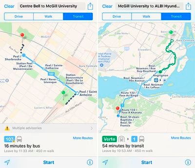
Apple-Maps-Montreal-Transit
Montreal Metro subway and STM bus directions are available throughout Greater Montreal, including the main island and throughout the suburbs of Blainville, Boucherville, Brossard, Châteauguay, Dollard-des-Ormeaux, Laval, Longueuil, Repentigny, Saint-Jérôme, Saint-Lambert, and Terrebonne.
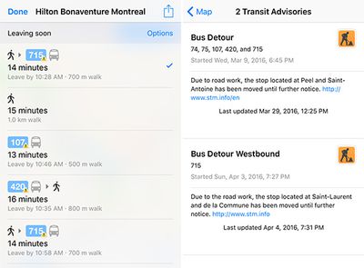
Apple-Maps-montreal-transit-2
Montreal is the second Canadian metro area to support Apple Maps transit after Toronto. However, as we reported last June, transit data actually extends to many cities throughout Southern Ontario, including Barrie, Mississauga, Oakville, Oshawa, Peterborough, Burlington, Hamilton, Guelph, KWC, York Region, and Niagara Region.

Other cities with Apple Maps transit directions include Baltimore, Berlin, Boston, Chicago, London, Los Angeles, Mexico City, New York City, Philadelphia, San Francisco, Sydney, and multiple Chinese metro areas. Transit mode was added to Apple Maps as one of the headline features of iOS 9 last year.

(Thanks, Olivier!)
Top Rated Comments

136 months ago
That first screenshot perfectly illustrates what's still wrong with Apple Maps and transit directions. I don't want to take transit for the sake of taking transit, I want the fastest way there and sometimes that means walking a few extra blocks and I don't see why I would have to toggle between walking and transit to see that.
Score: 5 Votes (Like | Disagree)
Joe Rossignol Avatar
136 months ago
The third screenshot is where it does exactly what you want. Walking is the 2nd option in the list.

I tried the McGill/Centre Bell directions and was given much more direct routes including the 24 minute walk option. Perhaps the article author didn't select the quickest route?
This was the case. I had deselected bus routes to get a subway-only screenshot for demonstrative purposes. But I've updated the screenshot now.
Score: 4 Votes (Like | Disagree)
n-evo Avatar
136 months ago
There are several dozens cities in the Toronto and Montreal regiion (in fact if you look at Toronto coverage, Apple and Google are pretty close in coverage), so in fact they just need to Cover Vancouver, Calgary, Edmonton, Ottawa to get 90% of the public transit in Canada, I expect them to get here by the end of the year. That's not that long since they launched.
I wasn't talking about Canada per se, Transit support as a whole. Worldwide. Google Maps covers the entire the Netherlands: trains, metros, trams, busses, regional busses, ferries, etc. from all transit authorities have real time data. Apple: none.

Kinda unforgiving in a country where public transportation is responsible for a large chuck of journeys made.
Score: 1 Votes (Like | Disagree)
136 months ago
Do the transit options include dog sleds? :D
[doublepost=1459881595][/doublepost]
Who needs Apple maps, when there is Google Maps? GM outperforms on every aspect.
When I click on an address in safari or mail, google map does not perform. Just saying.
Score: 1 Votes (Like | Disagree)
atikalz Avatar
136 months ago
Who needs Apple maps, when there is Google Maps? GM outperforms on every aspect.
Score: 1 Votes (Like | Disagree)
136 months ago
So at this rate they're adding one new city per month? Lol.
Score: 1 Votes (Like | Disagree)

Popular Stories

trump lake america

Apple Maps Renames Lake Ontario 'Lake America'

Tuesday September 1, 2026 1:58 pm PDT by
Apple Maps users in the United States will now see "Lake America" instead of "Lake Ontario" for the Great Lake on the border of Ontario and New York. The updated name is currently rolling out to iPhone, iPad, and Mac users. The Maps app still has the Lake Ontario label for the body of water, but tapping it now says "Lake America." Apple will likely change the label in the next few hours....
Apple Maps Google Maps Icons

Google Maps Showing 'Lake America' in U.S., Apple Maps Yet to Follow

Monday August 31, 2026 6:33 am PDT by
Google Maps users in the U.S. will now see the name "Lake America" instead of "Lake Ontario" for the Great Lake that straddles the New York—Ontario border. Google said it made this change in response to the U.S. Geographic Names Information System (GNIS) updating the name for "Lake Ontario" to "Lake America," following an executive order issued by U.S. President Donald Trump last week....
apple maps ads live

Apple Maps Ads Are Here, and There's No Way to Turn Them Off

Tuesday August 25, 2026 1:40 pm PDT by
Ads in Apple Maps are live in the United States and Canada, which means iPhone and iPad users will see them when searching for locations and when viewing Suggested Places. Apple announced plans to bring ads to the Maps app in March, and said the feature would roll out starting in late summer. Apple confirmed to 9to5Mac that ads began showing up for users over the last few days, with ad...