Google announced yesterday that it has begun rolling out new high-definition satellite imagery of Earth to its Google Earth and Google Maps apps.

The company said it was introducing a new cloud-free mosaic of the Earth's surface made up of high-resolution images taken by Landsat 8, a satellite deployed by the USGS and NASA in 2013.

Google Maps lo res

Google Earth image of New York City before update

Google Maps hi res
New Google Earth image of the same area after update

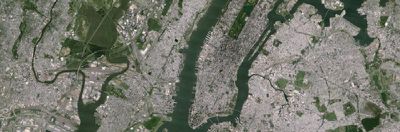
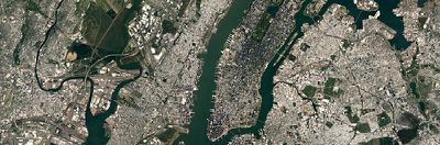
In a blog post announcing the update, Google explained that the seamless mosaic uses new processing techniques for sharper pictures, and was composed out of a mind-blowing amount of open access digital data:

To produce this new imagery, we used the same publicly available Earth Engine APIs that scientists use to do things like track global tree cover, loss, and gain; predict Malaria outbreaks; and map global surface water over a 30 year period.

Like our previous mosaic, we mined data from nearly a petabyte of Landsat imagery—that’s more than 700 trillion individual pixels—to choose the best cloud-free pixels. To put that in perspective, 700 trillion pixels is 7,000 times more pixels than the estimated number of stars in the Milky Way Galaxy, or 70 times more pixels than the estimated number of galaxies in the Universe.

Some users are reportedly still seeing old images in the app, and Google hasn't offered a specific timeline for completion of the update, which began on Monday. Users can check the blog post for more images and information on the satellite's history.

Google Maps is a free download from the App Store for iPhone and iPad. [Direct Link]

Google Earth is available to download for the Mac here.

Top Rated Comments

djcerla Avatar
91 months ago
Still 9-years old, low definition satellite imagery in my area, whereas Apple maps imagery is sharp, and updated.
Score: 7 Votes (Like | Disagree)
jackth29 Avatar
91 months ago
Conversation I was having less than an hour ago:
Score: 3 Votes (Like | Disagree)
341328 Avatar
91 months ago
Truly amazing work. Thanks
Score: 2 Votes (Like | Disagree)
MH01 Avatar
91 months ago
Google maps. Still way ahead of the competition .
Score: 2 Votes (Like | Disagree)
hanser Avatar
90 months ago
In Germany Apple Maps is also far ahead in resolution and actuality. Where I come from I could determine that the picture is from spring 2014, since I could see the fresh grave, covered with flowers, of somebody I knew... Google maps pictures are low rez, washed out and outdated by comparison. Lets see if it improves now.
Score: 2 Votes (Like | Disagree)
Zwhaler Avatar
91 months ago
This is the best news I've read on here in awhile!
[doublepost=1467112474][/doublepost]
In the future we'll see imagery in real time.
Government/military won't allow it I'm afraid.
Score: 2 Votes (Like | Disagree)

Popular Stories

google drive for desktop1

Google to Roll Out New 'Drive for Desktop' App in the Coming Weeks, Replacing Backup & Sync and Drive File Stream Clients

Tuesday July 13, 2021 1:18 am PDT by
Earlier this year, Google announced that it planned to unify its Drive File Stream and Backup and Sync apps into a single Google Drive for desktop app. The company now says the new sync client will roll out "in the coming weeks" and has released additional information about what users can expect from the transition. To recap, there are currently two desktop sync solutions for using Google...