
Google Maps Gains Real-Time 'Crowdedness' Transit Data, Live Food Delivery Status, and More - MacRumors
Skip to Content

Google Maps Gains Real-Time 'Crowdedness' Transit Data, Live Food Delivery Status, and More

Google Maps gained three new features today to help users stay safe amid the coronavirus pandemic, including an expansion of its live transit "crowdedness" status information.
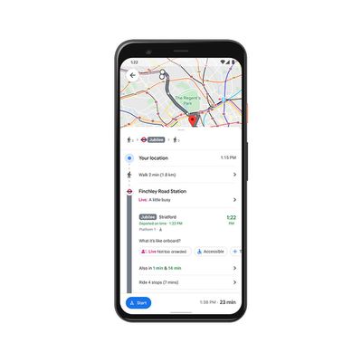
google maps crowdedness
Crowdedness data shows the real-time state of transit lines when users look up directions. The information is crowdsourced and relies on in-app feedback from users. Before today, Google Maps only showed the data for stations, but that has now been expanded to buses, trains, and subways.

Avoiding holiday crowds might have always been your thing, but this year, we’re making it especially easy for everyone. If you need to take transit, Google Maps can help you more easily social distance with live crowdedness information. On Android and iOS globally, you’ll start seeing how crowded your bus, train, or subway line is right now based on real-time feedback from Google Maps users around the world (wherever data is available).

In September, Google Maps rolled out a COVID-19 overlay that can show how cases are trending in areas so users can make informed decisions about traveling. The overlay showed the seven-day average of cases per 100,000 people and whether cases are rising and falling. From today, the overlay also shows the all-time number of confirmed cases and deaths, with links to local resources.

Finally, Google now shows the live status of takeout and delivery in the United States, Canada, Germany, Australia, Brazil and India when users book or order from Google Maps. As well as seeing expected wait times and delivery fees, users can reorder favorites right from within the app.

Google Maps can be downloaded from the App Store for free. [Direct Link]
Popular Stories

apple wallet drivers license feature iPhone 15 pro

Apple Says iPhone Driver's Licenses Will Expand to These 6 U.S. States

Thursday July 9, 2026 7:29 am PDT by
In select U.S. states, residents can add their driver's license or state ID to the Apple Wallet app on the iPhone and Apple Watch, and then use it to display proof of identity or age at select airports and businesses, and in select apps. To set up the feature, open the Wallet app on the iPhone and tap on the plus sign in the top-right corner. Next, tap on Driver's License and ID Cards,...
apple silicon 1 feature

Apple Silicon is Taking an Unexpected Turn

Friday July 10, 2026 7:24 am PDT by
Ever since the Mac switched from Intel processors to Apple silicon starting in 2020, each generation of M-series chips has included higher-end Pro and Max variants. If a recent report proves to be accurate, though, that streak will be coming to an end. According to Bloomberg's Mark Gurman, Apple will be releasing a regular M6 chip, but it has no plans to offer higher-end M6 Pro and M6 Max...
iphone 16 teal

'Siri AI' Lawsuit Update: Apple to Pay Owners of These iPhone Models

Thursday July 9, 2026 7:08 am PDT by
In May, Apple agreed to pay $250 million to settle a U.S. class action lawsuit over Siri AI's delayed launch, and eligible iPhone users could receive up to a $95 payout. This week, the California court overseeing the case held a hearing regarding preliminary approval of the settlement, but the judge has not yet issued a ruling. It will likely be at least a few more months before eligible...

Top Rated Comments

mw360 Avatar
74 months ago

Read the title and thought, “Yuck! Who is ordering live food?”
Isn't that exactly why we're all in this mess?
Score: 9 Votes (Like | Disagree)
74 months ago
'tis the season...

Google sees you when you're sleeping
Google knows when you're awake
Google knows if you've been bad or good
So be good for Google's sake!
Score: 3 Votes (Like | Disagree)
74 months ago

Is this what you see as an American logged into google maps looking at London? 'The' Regents Park..?
Interesting. I see that same, and I live within walking distance of it. Then I checked the Royal Parks website, and it seems like both "The Regent's Park" and "The Green Park" are actually official names. It makes some sense grammatically, but I've never heard either described with "The".

https://www.royalparks.org.uk/parks

Apple Maps has "The Regent's Park" as well.
Score: 2 Votes (Like | Disagree)
CarlJ Avatar
74 months ago
Read the title and thought, “Yuck! Who is ordering live food?”
Score: 2 Votes (Like | Disagree)
mazz0 Avatar
74 months ago

The information is crowdsourced and relies on in-app feedback from users
Huh, you'd think it could be done automatically (for opted-in users) based on regular pinging of other phones in bluetooth range. There must be enough Android phones in circulation to make that a pretty good guide to how busy your immediate area is.
Score: 2 Votes (Like | Disagree)
GeoStructural Avatar
74 months ago

Huh? I swear I have had the crowd on transit feature at least 2 years. It always asks me how full my bus, train etc was and shows me how full it is when I look up my next direction
Same here. Not since 2 years but for a good while. I guess we were Beta testers without knowing?

By the way, I love Google Maps, I still think it is king in the segment, but the more they add to it, the more convoluted it gets. I prefer when it was more intuitive and you didn't have to look twice for basic functionality. My usage interest is just navigation and exploration of new places.
Score: 1 Votes (Like | Disagree)