Mysterious Apple Van Captured on Video in Palo Alto Residential Neighborhood
A largely unmarked van with rooftop cameras, similar to the one originally spotted roaming Bay Area streets earlier this month, has been captured on video in Palo Alto, California. MacRumors obtained the footage from reader Jonathan Shiu, who recently recorded the van driving past Juana Briones Park on Clemo Avenue, a residential side street located approximately 10 miles from Apple's headquarters in Cupertino.
It has been increasingly speculated that these fifth-generation Dodge Caravans, which are reportedly leased to Apple, are part of the company's work on an electric car, but it is also possible that the vans are being used for a project similar to Google's Street View. It is conceivable that the rooftop cameras are being used to either collect mapping data for Apple Maps or as sensors to assist with self-driving initiatives.
Earlier this week, the Financial Times reported that Apple is hiring automotive experts to work in a top-secret research lab located near the company's headquarters. The Wall Street Journal soon followed up with a report claiming that Apple has hundreds of employees working on developing an electric vehicle, and Reuters added that the project will involve self-driving cars.
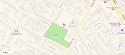
Clemo Avenue in Palo Alto, California, about 10 miles from Apple's HQ in Cupertino
Apple is likely in the early stages of research and development for any electric car project, and it is fully possible that the iPhone maker scraps the initiative before it ever reaches the public. With both Google and Tesla already invested in electric and self-driving vehicles, it will be interesting to see if Apple enters the industry or remains on the sidelines in the months and years ahead.
Popular Stories
Apple turns 50 this year, and its CEO Tim Cook has promised to celebrate the milestone. The big day falls on April 1, 2026.
"I've been unusually reflective lately about Apple because we have been working on what do we do to mark this moment," Cook told employees today, according to Bloomberg's Mark Gurman. "When you really stop and pause and think about the last 50 years, it makes your heart ...
While the iOS 26.3 Release Candidate is now available ahead of a public release, the first iOS 26.4 beta is likely still at least a week away. Following beta testing, iOS 26.4 will likely be released to the general public in March or April.
Below, we have recapped known or rumored iOS 26.3 and iOS 26.4 features so far.
iOS 26.3
iPhone to Android Transfer Tool
iOS 26.3 makes it easier...
Apple recently acquired Israeli startup Q.ai for close to $2 billion, according to Financial Times sources. That would make this Apple's second-biggest acquisition ever, after it paid $3 billion for the popular headphone maker Beats in 2014.
This is also the largest known Apple acquisition since the company purchased Intel's smartphone modem business and patents for $1 billion in 2019....
Apple plans to announce the iPhone 17e on Thursday, February 19, according to Macwelt, the German equivalent of Macworld.
The report, citing industry sources, is available in English on Macworld.
Apple announced the iPhone 16e on Wednesday, February 19 last year, so the iPhone 17e would be unveiled exactly one year later if this rumor is accurate. It is quite uncommon for Apple to unveil...
In the iOS 26.4 update that's coming this spring, Apple will introduce a new version of Siri that's going to overhaul how we interact with the personal assistant and what it's able to do.
The iOS 26.4 version of Siri won't work like ChatGPT or Claude, but it will rely on large language models (LLMs) and has been updated from the ground up.
Upgraded Architecture
The next-generation...