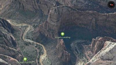
Apple has added two new locations to its Maps Flyover feature in iOS, including Tokyo, Japan and Zion National Park in Utah. The new additions to Flyover allow users to take a close 3D look at the areas, zooming in on buildings and landmarks.

First introduced with iOS 6 and based on technology acquired from the purchase of C3 Technologies, Flyover is now available in 88 different locations across the world.

zion_flyover

Zion National Park in Utah

The new additions to Flyover come as Apple works to continue to improve its Maps app. Recently, users have reported significant improvements in Apple Maps data, with errors being fixed with quick turnaround and additional POI locations added in many places. Apple also made notable updates to Maps in China, Japan, and several other countries back in March.

iOS 8 is expected to bring new features to Maps, though not at release. Transit directions and other Maps improvements are in the works, but may not be available to customers until the first significant iOS 8 update, possibly iOS 8.1, in 2015. iOS 8 also includes a new "City Tours" Flyover feature hidden within the code that lets users view a city's major points of interest via Flyover, but it is not yet unlocked.

Top Rated Comments

nagromme Avatar
152 months ago
Why don't they just put street view back?
Google won't let them, because Apple refused to share our private data with Google. Fair enough: both companies have to defend their business, and Apple's primary business is satisfied customers, while Google's is harvesting data.

There's no ideal outcome possible from that scenario, but I do like what we've got! A great Apple Maps app (thankfully, in my region) plus a Google app if you need it (but I never do).

What a waste of resources.

How about improving the overall mapping software than working on gimmicks Apple :apple:
That was exactly my thought.... at first.

I though Street View was terrfic for figuring out super-local details like which driveway goes with which building, or which doorway goes into which business. And I thought Flyover was a super-cool gimmick that I'd play with and forget.

In reality--since my city DOES have flyover (and I know that doesn't help everyone) I use it all the time, and it does what street view used to do, only MUCH BETTER.

Street view: your view is directly at the familiar street level perspective, and will look just the way you expect when you're there in person. Nice!

But...

- Your view is often in the wrong lane, taking the "familiar" advantage away.

- It's often blurred and smeared beyond recognition, noisy, poor contrast, and obscured by lens flares, so you can't read most of the signs you need anyway.

And...

Flyover view is WAY FASTER and WAY EASIER TO NAVIGATE.

Street View is such an awful experience (including terrible desktop navigation controls). Turn... turn some more... adjust... click to move forward... wait for loading... look around... oops, went down the wrong way... turn around again... turn some more... tap back where you came from... loading delay... turn again... click again... loading delay... can't quite see what I want... try a little farther ahead... loading delay... wish I could back up just a little... but I can't, I'm stuck with nodes 40 feet apart... give up.

Compare to Flyover: you can navigate instantly and smoothly using the SAME panning/zooming controls as 2D maps. It's not a separatre, awkward mode. It just works.

And you can easlly see the lay of the land, the driveways, etc. that Street View could show you. Not perfectly, but not worse either--just different. It turns out that the human brain actually has no trouble recognizing a place from an angle 50 feet in the air.

Try this experiment: find a square block of your city, and pretend you know a restaurant is in that area, and you know what it looks like but you don't remember the name. Now take a "walk" around that block, all the way around and back, four turns, in Street View. Now try it in Flyover.

No contest. You can spot the place in a few seconds in Flyover. With Street View you will spend minutes, and that's not counting the time you need to go get a shot of whisky to survive the hassle.

So let's hope Apple KEEPS expanding flyover like this. It doesn't help nearly enough people yet.
Score: 12 Votes (Like | Disagree)
152 months ago
Google won't let them, because Apple refused to share our private data with Google. Fair enough: both companies have to defend their business, and Apple's primary business is satisfied customers, while Google's is harvesting data.

There's no ideal outcome possible from that scenario, but I do like what we've got! A great Apple Maps app (thankfully, in my region) plus a Google app if you need it (but I never do).


That was exactly my thought.... at first.

I though Street View was terrfic for figuring out super-local details like which driveway goes with which building, or which doorway goes into which business. And I thought Flyover was a super-cool gimmick that I'd play with and forget.

In reality--since my city DOES have flyover (and I know that doesn't help everyone) I use it all the time, and it does what street view used to do, only MUCH BETTER.

Street view: your view is directly at the familiar street level perspective, and will look just the way you expect when you're there in person. Nice!

But...

- Your view is often in the wrong lane, taking the "familiar" advantage away.

- It's often blurred and smeared beyond recognition, noisy, poor contrast, and obscured by lens flares, so you can't read most of the signs you need anyway.

And...

Flyover view is WAY FASTER and WAY EASIER TO NAVIGATE.

Street View is such an awful experience (including terrible desktop navigation controls). Turn... turn some more... adjust... click to move forward... wait for loading... look around... oops, went down the wrong way... turn around again... turn some more... tap back where you came from... loading delay... turn again... click again... loading delay... can't quite see what I want... try a little farther ahead... loading delay... wish I could back up just a little... but I can't, I'm stuck with nodes 40 feet apart... give up.

Compare to Flyover: you can navigate instantly and smoothly using the SAME panning/zooming controls as 2D maps. It's not a separatre, awkward mode. It just works.

And you can easlly see the lay of the land, the driveways, etc. that Street View could show you. Not perfectly, but not worse either--just different. It turns out that the human brain actually has no trouble recognizing a place from an angle 50 feet in the air.

Try this experiment: find a square block of your city, and pretend you know a restaurant is in that area, and you know what it looks like but you don't remember the name. Now take a "walk" around that block, all the way around and back, four turns, in Street View. Now try it in Flyover.

No contest. You can spot the place in a few seconds in Flyover. With Street View you will spend minutes, and that's not counting the time you need to go get a shot of whisky to survive the hassle.

So let's hope Apple KEEPS expanding flyover like this. It doesn't help nearly enough people yet.

Agreed. My city (Copenhagen) has had flyover from the beginning. I have used it a TON. It is by far the best way to show people a place. It is the easiest way to understand and recognize an area.
Score: 3 Votes (Like | Disagree)
springsup Avatar
152 months ago
Still missing many European capitals. Amsterdam & Brussels for instance.

Tokyo does look pretty cool, though.
Score: 3 Votes (Like | Disagree)
152 months ago
Apple maps flyover simply doesn’t compare to street view, in terms of detail, apple’s 3D mode is woeful, you can’t even tell this building is a KFC using apple maps, compared to being able to see how much the original recipe bites cost, when using google street view. :p
Image (http://i.imgur.com/3lxm3Qy.jpg)
I can tell it's a KFC because the pin says "Kentucky Fried Chicken." :P

And who knows how old that Street View photo is - the price has likely changed since it was taken.

And am I seeing things, or did Google blur the Colonel's face on the sign on the building? :P
Score: 2 Votes (Like | Disagree)
152 months ago
I'm a big fan of fly over. It is a fun way to re live vacations to supported destinations. That said they need to better cache the area around your view so as to reduce the popup from texture streaming.
For the people complaining that Apple is working on this, seriously don't worry about it. This is a very different talent set from traditional mapping/navigation. Nobody is being pulled from other areas of the mapping team to work on these. Apple is a huge company and has really built an impressive mapping solution in a short time. Sure they have some ways to go still, but let's be honest, the relationship with Google was preventing iOS maps for progressing. Apple had to dump Google maps if they wanted to get turn by turn directions. The upside is we quickly went from no good free navigation app (sorry Waze, but you were young back then), to having several quality options to choose from.
Score: 2 Votes (Like | Disagree)
152 months ago
What a waste of resources.

How about improving the overall mapping software than working on gimmicks Apple :apple:

I'm still awestruck every time I see one of the 3D Maps
Score: 2 Votes (Like | Disagree)

Popular Stories

Apple Announces Special Event in New York Feature

Apple Announces Special Event in New York, London, and Shanghai on March 4

Monday February 16, 2026 6:05 am PST by
Apple today announced a "special Apple Experience" in New York, London, and Shanghai, taking place on March 4, 2026 at 9:00am ET. Apple invited select members of the media to the event in three major cities around the world. It is simply described as a "special Apple Experience," and there is no further information about what it may entail. The invitation features a 3D Apple logo design...
CarPlay Liquid Glass Dark

iOS 26.4's New CarPlay Video Feature Shown in Action

Wednesday February 18, 2026 9:29 am PST by
Back at WWDC 2025, Apple revealed that it was planning to allow CarPlay users to watch video via AirPlay in their vehicles while they are not driving, and the first beta of iOS 26.4 suggests the feature may be nearing availability. There are several new references to CarPlay video streaming functionality within the iOS 26.4 beta's source code. The feature is not yet visible to users, but...
iphone 16 apple intelligence

Apple Aiming to Release 'Breakthrough' New iPhone Accessory

Wednesday February 18, 2026 12:43 pm PST by
Apple is looking for a "breakthrough" with its push into wearable AI devices, including an "AirTag-sized pendant," according to Bloomberg's Mark Gurman. In a report this week, he said the pendant is reminiscent of the failed Humane AI Pin, but it would be an iPhone accessory rather than a standalone product. The pendant would feature an "always-on" camera and a microphone for Siri voice...
Apple Announces Special Event in New York Feature 1

Apple Event on March 4: Here's What to Expect

Tuesday February 17, 2026 8:08 am PST by
Apple on Monday invited selected journalists and content creators to a "special Apple Experience" on Wednesday, March 4 in New York, London, and Shanghai. At an Apple Experience, attendees are typically given the opportunity to try out Apple's latest hardware or software. Following the launch of Apple Creator Studio last month, for example, some content creators attended an Apple Experience...
iphone 17 pro green

iPhone 17 Pro Max Curiously Becomes Most Traded-In Smartphone

Wednesday February 18, 2026 9:13 am PST by
New trade-in data indicates that Apple's iPhone 17 Pro Max has rapidly become the single most traded-in smartphone. According to a new report from SellCell, Apple's latest flagship iPhone has quickly risen to the top of the independent trade-in market, accounting for 11.5% of all devices appearing in the top-20 trade-in rankings just months after release. The analysis is based on SellCell...