Transit
By MacRumors Staff
Transit Articles
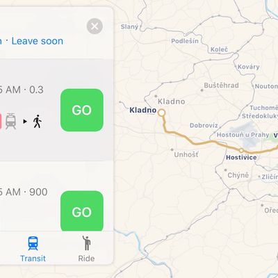
Apple Maps Transit Directions Expand to Prague, Czech Republic
Apple continues to slowly expand the transit functionality of Apple Maps, today adding Prague, Czech Republic as the third city in Europe behind London and Berlin to be supported.
Apple Maps transit data in Prague includes the Prague Metro and Esko Prague commuter rail, as well as local trams and buses and even Czech Railways' seasonal Cyklohráček "excursion train" targeting cyclists and...
Read Full Article 23 comments
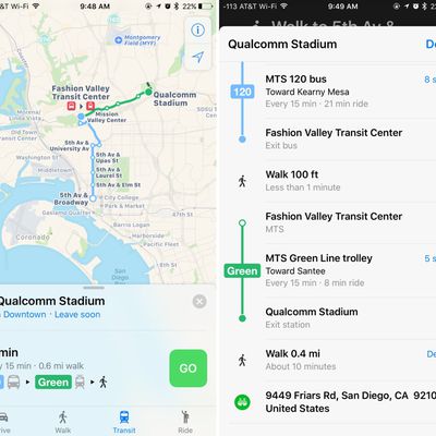
Apple Maps Expands Transit Data to San Diego and British Columbia
Apple recently updated its Maps app to include transit information in San Diego, California and British Columbia, Canada allowing iOS users in those locations to incorporate public transportation options when seeking directions through the Apple Maps app.
In San Diego, Apple Maps will now offer up routes that include transportation by the city's Trolley, which connects the east and south...
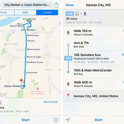
Apple Maps Expands Transit Data to Honolulu and Kansas City
Apple Maps has been updated with comprehensive transit data for the U.S. cities of Honolulu, Hawaii and Kansas City, Missouri, enabling iPhone users in the areas to navigate using public transportation, including buses and commuter rails.
Transit routing options in the Kansas City metropolitan area include RideKC buses and the downtown KC Streetcar. Directions extend to most suburbs in both...
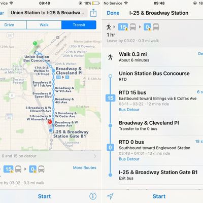
Apple Maps Introduces Transit Data for Denver, Colorado
Apple Maps has been updated with comprehensive Transit information for the city of Denver, Colorado, enabling iPhone users in the area to navigate using public transportation, including buses, subways, and commuter rails.
Transit routing was introduced in iOS 9 with support for a limited number of cities, but Apple has since expanded its public transportation coverage for over 20 cities...
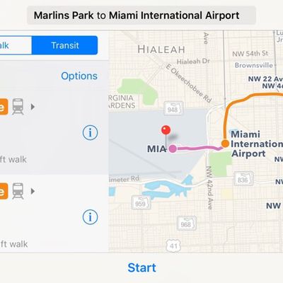
Transit Directions Expand to UK National Rail, Atlanta and Miami
Ahead of the 2016 Worldwide Developers Conference, Apple's Maps team is working hard to expand transit directions to additional locations. Starting this morning, transit information in the United Kingdom has expanded to encompass the National Rail, which represents several public transportation systems across Great Britain.
In the United States, transit directions are now available in Atlanta...
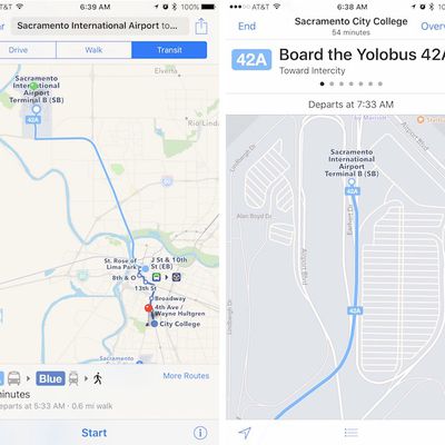
Apple Maps Introduces Transit Data for Sacramento, California
Apple Maps has recently been updated with the introduction of all new Transit information for the city of Sacramento, California, which will let iPhone users in the city navigate using public transportation options like buses, subways, commuter rails, and more.
Transit routing became available within iOS 9 with a limited number of supported cities at launch. Since then, Apple has worked at...
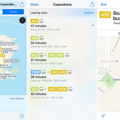
Apple Maps Gains Transit in Rio de Janeiro Ahead of Summer Olympics
In time for the 2016 Summer Olympics, Apple Maps now supports transit routing in Rio de Janeiro, the second most populous city in Brazil.
Transit directions are available for travel by bus, ferry, metro, and train throughout the Rio de Janeiro metropolitan area, including connections to and from Belford Roxo, Duque de Caxias, Itaboraí, Japeri, Magé, Mesquita, Nilópolis, Niterói, Nova...
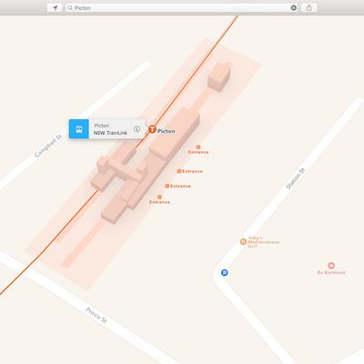
Apple Maps Expands Transit Data in New South Wales, Australia With TrainLink and Bus Routes
Apple Maps has recently been updated with all-new transit data for New South Wales, Australia, allowing iOS users to navigate the area with the new addition of the NSW TrainLink line as well as bus stations. Before the update, only rail directions for Sydney Trains were available. Sydney, and now New South Wales as a whole, are still the only areas in Australia with Transit information available.
...
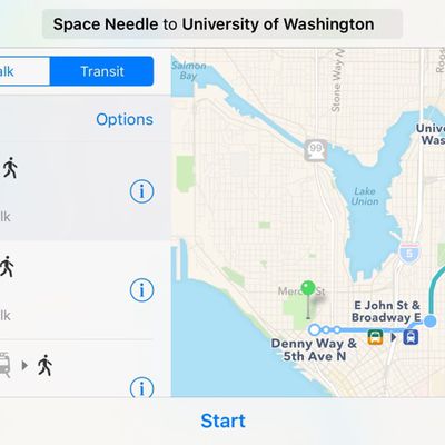
Apple Expands Maps Transit Directions to Seattle, Washington
Apple today updated its Maps app to add Transit information in Seattle, allowing iOS users living in the city to incorporate public transportation options like the Link Light Rail, Monorail, buses, and more into Maps when seeking directions.
Transit directions within Maps became available with the launch of iOS 9, and while Apple offered directions in a limited number of cities to begin with,...
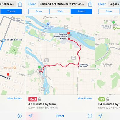
Apple Maps Expands Transit Data to Portland, Oregon
Apple Maps has been updated with all-new transit data in Portland, providing users with aerial tram, bus, MAX light rail, WES commuter rail, and downtown streetcar routing in Oregon's most populous city and the surrounding metropolitan area. The public transit information is supplied by the city and regional transportation agency TriMet.
Apple Maps transit routing and trip planning is...
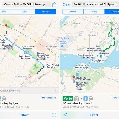
Apple Maps Expands Transit Data to Montreal
Apple Maps has been updated with all-new transit data in Montréal, providing users with bus, subway, and train routing in Canada's second most populous city. The public transit information is supplied by the city's public transport agencies Agence métropolitaine de transport (AMT) and Société de transport de Montréal (STM).
Montreal Metro subway and STM bus directions are available...
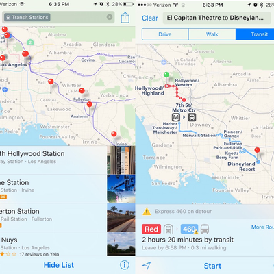
Los Angeles Public Transit Information Added to Apple Maps
As noted by IT professional and writer Tom Bridge on Twitter, public transit information for Los Angeles has started to go live in Apple Maps on both iOS and El Capitan. The rollout adds another major city to a feature that launched as part of iOS 9.
Transit information may still be rolling out to users. Support will include train, light rail and bus services in addition to transit...
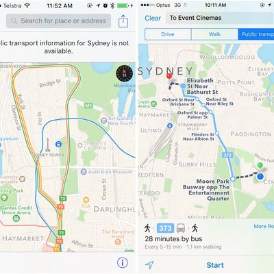
Transit Directions for Sydney, Australia Going Live in Apple Maps
Several users are reporting seeing transit directions going live for Sydney, Australia in Apple Maps today, adding another major city for the the feature launched as part of iOS 9. Not all users are seeing transit routes for Sydney yet, but support is clearly rolling out at the moment for light rail, commuter rail, buses, and ferry service.
Apple added both Boston and Sydney to its list of...
Apple Maps Adds Amtrak Routes in Northeastern U.S. and Transit Directions for Boston
As part of its efforts to add transit directions in iOS 9, Apple has recently updated Apple Maps to include multiple Amtrak routes in the Northeastern United States. Available mainly in the cities where transit directions have been implemented, the longest Amtrak route available runs from Chicago to New York.
Supported routes include the Northeast Regional, Acela Express, Keystone, Lake Shore...

Apple Expanding Maps Transit Directions to Boston and Sydney
Apple today updated its iOS 9 features page to highlight two new cities where transit directions in the Maps app are now available: Sydney, Australia and Boston, Massachusetts. Sydney and Boston are the first two cities to gain transit information beyond the first wave launch cities.
Transit directions within Maps became available alongside the launch of iOS 9. The first areas that...
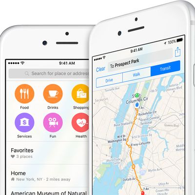
Inside iOS 9: Apple Maps Gains Transit Mode and Nearby Search
Apple Maps launched in September 2012 as the default mapping app on iPhone, but soon faced widespread criticism for having incomplete data, providing incorrect directions and lacking features over Google Maps. The controversial launch resulted in Apple CEO Tim Cook issuing a rare public apology, while former iOS chief Scott Forstall was ousted from Apple just one month later.
While there is...
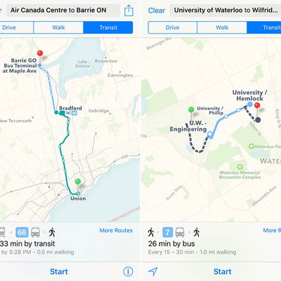
Apple Maps Transit Directions Work Across Much of Greater Toronto Area
Apple earlier this week announced that Toronto will be one of ten major cities in North America that will support Apple Maps transit directions on iOS 9 in the fall, but after early testing we can confirm that the new routing option for bus, subway, light rail, train and ferry directions will actually extend well beyond the city limits and TTC to cover much of the Greater Toronto Area and...