Apple Maps Transit Directions Now Available in Calgary and Southern Alberta - MacRumors
Skip to Content

Apple Maps Transit Directions Now Available in Calgary and Southern Alberta

by

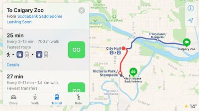
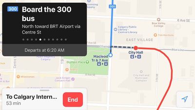
Apple Maps has been updated with comprehensive transit data in Calgary, Alberta, enabling iPhone users in the Canadian city to navigate with public transportation, including the CTrain light rail system and buses.

apple maps calgary transit 1
Apple Maps transit directions are also available for buses in the smaller Southern Alberta cities of Red Deer, Lethbridge, and Medicine Hat.

Apple Maps enabled transit routing in Calgary just in time for the 2017 Calgary Stampede, which runs between July 7 and July 16.

Apple Maps gained a Transit tab in iOS 9. The feature lags several years behind Google Maps, but Apple's public transportation support is exhaustive, mapping all station entrances and listing departure times.

apple maps calgary transit 2
At launch, the feature was limited to Baltimore, Berlin, Boston, Chicago, London, Los Angeles, Mexico City, New York, Philadelphia, San Francisco, Sydney, Toronto, and over 300 cities in China. Since then, Apple has been working to expand support for public transportation to other cities around the world.

Newer additions include Atlanta, Columbus, Dallas, Denver, Detroit, Honolulu, Houston, Kansas City, Madrid, Manchester, Melbourne, Miami, Minneapolis–Saint Paul, Montréal, New Orleans, Paris, Portland, Pittsburgh, Prague, Rio de Janeiro, Sacramento, Salt Lake City, San Antonio, San Diego, Seattle, and Singapore.

For a complete list of cities with Apple Maps transit directions, visit the iOS Feature Availability page on Apple's website.

(Thanks, Bernd!)

Top Rated Comments

surfingarbo Avatar
114 months ago
Yeay! I’m from Calgary. Exciting! :)
Score: 5 Votes (Like | Disagree)
surfingarbo Avatar
114 months ago
Now watch as Apple, much like the rest of Canada, forgets that Edmonton has essentially the same population as Calgary.

And actually, now that I think about it, how on earth is this not available in Vancouver of all places? Probably the most comprehensive transit system in the country.
Edmonton is coming soon. You can see that they’ve started to map out the LRT stations in red, and have also added bus stops.

Attachment Image
Score: 3 Votes (Like | Disagree)
DingeZ Avatar
114 months ago
"One city at a time" isn't exactly accurate. It is mostly a cluster of cities, situated around a mayor city (Calgary in this case) and they have released whole countries at once before (Japan, GB & the Netherlands). But the reason why is because they want to do it right. Every city has its specifics, but while Google only dumps the data in the system and then draws straight lines between the stations, Apple draws all lines geographically accurate and includes the lay-out of stations with entrances and exits. Also, Apple adheres to local conventions, like east-, west-, out- or inbound, or even complex train numbering codes like in Paris.
Score: 3 Votes (Like | Disagree)
114 months ago
Now watch as Apple, much like the rest of Canada, forgets that Edmonton has essentially the same population as Calgary.

And actually, now that I think about it, how on earth is this not available in Vancouver of all places? Probably the most comprehensive transit system in the country.
Score: 2 Votes (Like | Disagree)
114 months ago
Edmonton is coming soon. You can see that they’ve started to map out the LRT stations in red, and have also added bus stops.
Someone up at Apple cares that we exist!
Score: 1 Votes (Like | Disagree)
Corrode Avatar
114 months ago
Timing coincides with the first day of Calgary Stampede. Goes to show that if you want your city added, just hold a big event.
Score: 1 Votes (Like | Disagree)