Apple Maps now supports navigation with public transportation in most metropolitan areas of Ohio, Maryland, Arkansas, and West Virginia.
By selecting the Transit tab in Apple Maps on iPhone, iPad, or Mac, users in each state can now access bus and train routes where available, complete with arrival and departure times, service advisories, and other detailed information.
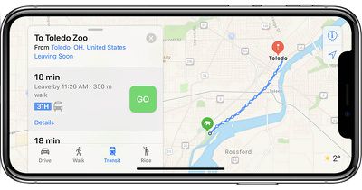
The statewide expansions build upon the feature's availability in larger cities. Apple Maps users in Ohio, for example, can now navigate with transit in the Dayton, Toledo, and Akron areas, joining Cleveland, Cincinnati, and Columbus.
Additional supported areas include Little Rock in Arkansas, Frederick in Maryland, and Charleston in West Virginia.
Apple Maps has aggressively expanded its transit-supported cities over the past two months to include St. Louis, Missouri; Richmond, Virginia; Norfolk, Virginia; Tucson, Arizona; Albuquerque, New Mexico; Orlando, Florida; and Columbia, Charleston, and Greenville in South Carolina.
When the feature launched in 2015, it was initially limited to Baltimore, Berlin, Boston, Chicago, London, Los Angeles, Mexico City, New York, Philadelphia, San Francisco, Sydney, Toronto, and around 300 cities in China.
A complete list of supported cities can be found on Apple's iOS Feature Availability page. A reliable tipster has informed MacRumors that Charlotte, Nashville, Oklahoma City, Tulsa, Wichita, Indianapolis, Grand Rapids, Lansing, Brunswick, and Portland, Maine are candidates for the feature's continued rollout this month.


Top Rated Comments
Wish they’d get good at the core functionality before they go trying to map out museums and dog parks in Siberia.
I wonder how many different transit systems that Apple needs to work with, or if they require each transit board to add compatibility for Apple Maps API?