Google Maps Gains Landmark Aerial Views, Location Sharing Notifications for Arrival and Departure, and More - MacRumors
Skip to Content

Google Maps Gains Landmark Aerial Views, Location Sharing Notifications for Arrival and Departure, and More

Google is rolling out some new Maps features to its iOS and Android apps for the summer, including new location sharing options, cycling directions enhancements, and photorealistic aerial views of famous city landmarks.

Google maps feaure
First, location sharing. Google says it wants to make it easier to see when someone who has shared their location with you arrives or leaves a place, "so you can more easily coordinate schedules" and meetups. To that end, it's introducing location sharing notifications, which work similarly to the equivalent feature in Apple's Find My app.

Google offers the following use case:

Say you're headed to a concert with a group of friends. If they've already chosen to share their location with you, you can set a notification for the concert venue's address so you can see when they've arrived and meet up quickly. You could also set a notification to see when they've left the venue — just in case you get split up.

Google says it has built the feature with privacy in mind, which is why notifications can only be set for someone who has already chosen to share their location with you. In addition, that person will receive multiple reminders to let them know they are sharing their location, in the form of push notifications and recurring monthly emails, and users can stop sharing their location anytime.

Next up, Google is adding more granular information to cycling directions in the more than 100 cities where they are available, including things like whether a particular route involves a major or a minor road, if the route suggested includes stairs or steep hills, and when you should be prepared to encounter heavy traffic.

Aerial Views of Landmarks google
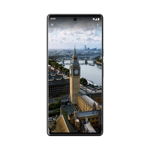
Lastly, Google is bringing photorealistic aerial views of "nearly 100 of the world's most popular landmarks" in cities including Barcelona, London, New York, San Francisco, and Tokyo. Google says the aerial views are a "first step" toward integrating its immersive view feature for cities that the company previewed in May and which is scheduled to roll out later this year.

Google says the aerial views of landmarks and location sharing notifications are rolling out now globally on Google Maps on Android and iOS, with cycling route information launching in the coming weeks in those cities where cycling directions are available.

Popular Stories

HomePod mini and Apple TV Sage

New Apple TV and HomePod Mini Are 'Nearly Ready' to Launch, New Siri Remote Also Rumored

Sunday May 31, 2026 8:47 am PDT by
New models of the Apple TV 4K and HomePod mini are "nearly ready to go," according to the latest word from Bloomberg's Mark Gurman. Subscribe to the MacRumors YouTube channel for more videos. Both devices have been ready "for months," but Apple is holding off on launching them until the more personalized version of Siri is available, he said. "I am told the hardware for the next Apple TV...
Apple Wallet

iOS 27 Will Add Two New Apple Wallet Features to Your iPhone

Monday June 1, 2026 12:15 pm PDT by
Apple is set to unveil iOS 27 during its WWDC 2026 keynote on Monday, June 8, and the update will reportedly include two new Apple Wallet features. First, iOS 27 will reportedly let users create their own digital passes by scanning items like movie tickets, concert passes, and gym membership cards. Many apps already offer Apple Wallet passes, but now users will be able to create a custom...
Apple Foldable Thumb

First 'Confirmed' iPhone Ultra Color Allegedly Revealed in Leaked Image

Monday June 1, 2026 4:39 am PDT by
Apple is expected to launch its first foldable iPhone later this year. Rumors suggest the "iPhone Ultra" will come in two color options, and a leaker shared an image today that allegedly shows one of them. Posted on Weibo by the Chinese leaker known as Ice Universe, the image purportedly offers a first glimpse of Apple's foldable in white. The device is believed to have entered early mass...

Top Rated Comments

50 months ago
Really puts Apple Maps in the mud.

Every few months I try using it again and it's still nowhere near the functionality or accuracy of Google Maps
Score: 16 Votes (Like | Disagree)
LV426 Avatar
50 months ago

It’s the traffic routing for me. Apple Maps doesn’t seem to really know where the traffic is, and even when it does it doesn’t take any evasive action.
My experience is completely the opposite. I often see amber and red line routes ahead as slow or stopped traffic is detected. And, on multiple occasions, I've had Apple maps notify me that a suggested route change will save X minutes.

Perhaps you live in Androidville! Apple infers traffic information by their servers analysing the location of millions of vehicles with iPhones in them.
Score: 9 Votes (Like | Disagree)
iDento Avatar
50 months ago
Great new features for an already great app, but... the UI is so cluttered I hate to use most of these features.
Score: 7 Votes (Like | Disagree)
50 months ago
The Big Ben one has fake 3d cars driving 'through' real parked cars... :oops:

I don't see the point of this, it doesn't even seem to be interactive... just a video.
Score: 7 Votes (Like | Disagree)
Kylo83 Avatar
50 months ago
Just checked the Big Ben london video and it’s really bad quality
Score: 5 Votes (Like | Disagree)
dugbug Avatar
50 months ago

My experience is completely the opposite. I often see amber and red line routes ahead as slow or stopped traffic is detected. And, on multiple occasions, I've had Apple maps notify me that a suggested route change will save X minutes.

Perhaps you live in Androidville! Apple infers traffic information by their servers analysing the location of millions of vehicles with iPhones in them.
honestly apple maps has been fantastic both for routes and traffic. Im in the US, that probably makes a difference.
Score: 4 Votes (Like | Disagree)