Google Maps Gains Enhanced Street-Level Detail in Four Major Cities
Google Maps has quietly been updated to include significantly more detailed street-level information in a handful of key cities around the world.
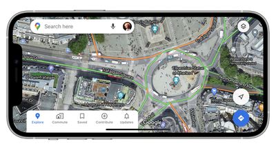
Upon zooming in, Google's maps for Central London, Tokyo, San Francisco, and New York now benefit from shapes and widths that match the scale of roads more accurately.
Meanwhile, enhanced graphical representations of sidewalks, crosswalks, pedestrian islands, and street-side flora have also been added, which should help users who rely on the maps for walking directions.
Lastly, parks now show the actual width of pathways in dark green along with any stairs in grey, offering improved accessibility information for wheelchair users or people with a stroller.
Some of the improvements are undoubtedly subtle, but underline Google's commitment to improving city-wide coverage. The changes are server-side and therefore require no software update, and Google says it plans to expand the new details to additional cities in the future.
Google Maps can be downloaded from the App Store for free. [Direct Link]
(Via AndroidPolice.)
Popular Stories
Phishing attacks taking advantage of Apple's password reset feature have become increasingly common, according to a report from KrebsOnSecurity. Multiple Apple users have been targeted in an attack that bombards them with an endless stream of notifications or multi-factor authentication (MFA) messages in an attempt to cause panic so they'll respond favorably to social engineering. An...
iOS 18 will give iPhone users greater control over Home Screen app icon arrangement, according to sources familiar with the matter. While app icons will likely remain locked to an invisible grid system on the Home Screen, to ensure there is some uniformity, our sources say that users will be able to arrange icons more freely on iOS 18. For example, we expect that the update will introduce...
At least some Apple software engineers continue to believe that iOS 18 will be the "biggest" update in the iPhone's history, according to Bloomberg's Mark Gurman. Below, we recap rumored features and changes for the iPhone. "The iOS 18 update is expected to be the most ambitious overhaul of the iPhone's software in its history, according to people working on the upgrade," wrote Gurman, in a r...
Apple today announced that its 35th annual Worldwide Developers Conference is set to take place from Monday, June 10 to Friday, June 14. As with WWDC events since 2020, WWDC 2024 will be an online event that is open to all developers at no cost. Subscribe to the MacRumors YouTube channel for more videos. WWDC 2024 will include online sessions and labs so that developers can learn about new...
Apple may be planning to add support for "custom routes" in Apple Maps in iOS 18, according to code reviewed by MacRumors. Apple Maps does not currently offer a way to input self-selected routes, with Maps users limited to Apple's pre-selected options, but that may change in iOS 18. Apple has pushed an iOS 18 file to its maps backend labeled "CustomRouteCreation." While not much is revealed...
The next-generation iPad Pro will feature a landscape-oriented front-facing camera for the first time, according to the Apple leaker known as "Instant Digital." Instant Digital reiterated the design change earlier today on Weibo with a simple accompanying 2D image. The post reveals that the entire TrueDepth camera array will move to the right side of the device, while the microphone will...
Apple today released macOS Sonoma 14.4.1, a minor update for the macOS Sonoma operating system that launched last September. macOS Sonoma 14.4.1 comes three weeks after macOS Sonoma 14.4. The macOS Sonoma 14.4.1 update can be downloaded for free on all eligible Macs using the Software Update section of System Settings. There's also a macOS 13.6.6 release for those who...
Top Rated Comments
“Apple releases new 3D flyovers in four major cities. This is what everyone cares about - the flyovers. Right? RIGHT?!”
It has gotten so much better in the States that for the third time I am using it as my main navigation app, in the past I tried and it was just not on par with the competition, I can see the improvements now.
It still has a long way to go, they could work on:
1. Better handling of pins and coordinates, this is important for professionals like geologists, engineers, biologists, etc.
2. More detailed turn-by-turn navigation, it is still behind the precision and detail offered by Google Maps. Apple Maps sometimes tells me "the next exit" I have to take but it would not tell me the exit number, which is something I would like to know in advance.
3. Public transportation implementation. Even though I can find routes in my city, some of them are even routes that have been eliminated. In contrast Google Maps tells me exactly where the bus is in REAL TIME, I can literally track it and not just rely on an ETA.
4. And most importantly: OFFLINE functionality. Several mapping apps in the store offer me to download maps for offline usage, but Apple Maps will not let me do that, it is frustrating as I work on the field constantly and cellphone reception is not available most of the time.
they are free to take photos of my street and obscure faces and license plates just like google does.
That old trope that gets pedalled around here is so tired.