Apple today updated its iOS feature availability page with 30 new Flyover locations around the world, including cities in the United States, Germany, Italy, Japan, Mexico, Spain, and the United Kingdom.
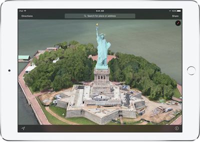
Flyover is an Apple Maps feature that provides photo-realistic 3D views of primarily large cities and landmarks. In satellite view, users can zoom, pan, and rotate to get a closer look at notable points of interest in supported regions.
The full list of new Flyover locations is available below, but some areas may only now be reflected on Apple's website:
United States
- Catalina Island, California
- Pinnacles National Park, California
- Porterville, California
- Visalia, California
- Tallahassee, Florida
- Martha's Vineyard, Massachusetts
- Springfield, Massachusetts
- Omaha, Nebraska
- Poughkeepsie, New York
- Rochester, New York
- Allentown, Pennsylvania
- Columbia, South Carolina
International
- Leipzig, Germany
- Naples, Italy
- Palermo, Italy
- Akita, Japan
- Hagi, Japan
- Hakodate, Japan
- Hamamatsu, Japan
- Kumamoto, Japan
- Tsunoshima, Japan
- Acapulco, Mexico
- Cuernavaca, Mexico
- Hermosillo, Mexico
- La Paz, Mexico
- Oaxaca, Mexico
- Puebla, Mexico
- Gijon, Spain
- Vigo, Spain
- Stoke-on-Trent, United Kingdom
Additionally, Apple Maps traffic data is now available in Chile, Hungary, and Vatican City.


Top Rated Comments
Look, each to their own. But I think it's a great tool.
I'm a photographer and often have to shoot in different parts of the city that I live in and in cities that I don't know well. Flyover has been invaluable. Just this week, I met with a wedding couple who I'm shooting and we sat down and planned their wedding itinerary and found shoot locations using Flyover. They asked me what app I was using and were surprised when I said Apple Maps.
When all the system will be in place, the experience will be like magic, resembling a drone view, unlike the poor user experience of today's Google street view (in other ways, a very useful service).
It's almost unbelievable folks continue to bitch about flyover, completely missing the big picture.