Since at least July 4, Apple Maps has failed to treat the privately-operated Highway 407 ETR in the Toronto, Canada area as a toll road, according to complaints from affected users. This issue is not limited to any particular device or software version, with users experiencing the problem across the iPhone, iPad, Mac, Apple Watch, and web.
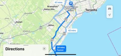
As a result of this issue, local Apple Maps users who have turned on the "Avoid Tolls" setting may still be routed onto the Highway 407 ETR when using turn-by-turn directions. This can prove to be a very costly mistake, as the highway is notoriously expensive, with rates of up to 85 cents (CAD) per kilometer traveled for passenger vehicles.
MacRumors was able to reproduce the issue, and alerted Apple to the matter shortly before publishing, so hopefully a fix is implemented soon.
As of June 1, the Ontario government stopped collecting tolls on the provincially-owned segment of Highway 407, which runs immediately east of the privately-operated ETR segment. Apple likely updated its Maps app to reflect this change, but perhaps it mistakenly treated the entire Highway 407 as a toll-free road.
If you scroll to the bottom of the Apple Maps menu, there is a "Report an Issue" button that allows you to alert Apple to this issue.
With the issue now receiving media coverage, it should be in the rearview mirror soon enough.
Thanks, John Naismith!
Update: Apple fixed the issue as of July 11.
Top Rated Comments
It’s used as an alternative to Highway 401, which is the busiest highway in North America. Busier than the 405 believe it or not.
Yes, it can save you significant time given the traffic in and around the Toronto area but you’re billed on a per kilometre basis and depending on the time of day, day of the week, it is very expensive to drive from one end to the other.
Like, north of $50CAD, that’s about $37USD, one way! Do that multiple times a week, and it adds up very quickly.
I assume what happened here is Apple stopped treating it as a toll highway because a small section of it is no longer being tolled.
The vast majority of it still being tolled as it is privately owned.
Drivers should read the signs instead of blindly following what the GPS is suggesting them to go.
How about some options like: reduced toll, eco route, reduce metropolitan areas, etc
Avoiding all tolls can add hours and be counter productive, but reduced tolls to maybe avoid some $$ bridges and tunnels would be such a no brainer. Some other old school route planners had it. Apple maps? nah. Straight for the most major citues, biggest congestion areas, most bridges & tunnels, plus toll roads!!
If you drive up or down the east coast, you have to add deliberate stops inland, to trick maps to steer you away from NY, NJ, ...
You can't use " avoid tolls " or you would add who knows how many hours to a trip. But there should be easy options to avoid metropolitan areas like Boston, New York, Baltimore, Washington, ...
Let's go around these places, avoid the congestion, the stop and go traffic, ...