Skip to Content

Apple Maps Launches Revamped Data Collection Website

As part of its efforts to rebuild Apple Maps "from the ground up," Apple has been collecting street-level data with LiDAR-equipped vehicles for over three years. Apple also deployed employees wearing LiDAR-equipped backpacks to collect pedestrian-based data starting in California late last year.

apple maps image collection
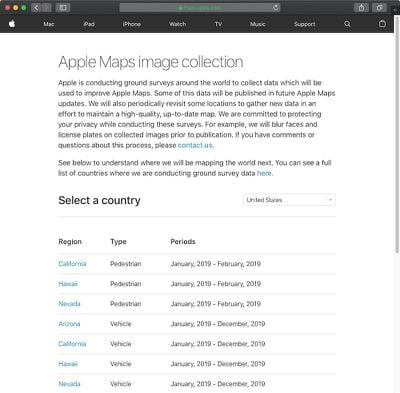
As these efforts expand around the world, Apple recently transitioned to a revamped Apple Maps image collection website with a list of locations it will be surveying both in vehicles and on foot in the upcoming months.

The page reveals a few new pieces of information, including that pedestrian-based data collection has expanded to Hawaii and Nevada through February. Vehicle-based data collection will also be expanding to the tiny European country of Andorra, landlocked between France and Spain, in April 2019.

The new page, which replaces the previous Apple Maps vehicles list, also indicates that Apple will "periodically revisit some locations to gather new data in an effort to maintain a high-quality, up-to-date map."

Apple Maps vehicles have been collecting mapping data in the United States since 2015, with over 45 states at least partially surveyed to date. The vehicles have also surveyed parts of Croatia, France, Ireland, Italy, Japan, Portugal, Slovenia, Spain, Sweden, and the United Kingdom, according to Apple.

Back in June 2018, Apple said the revamped mapping data would roll out section by section across the rest of the United States over the following year. The improvements first rolled out in Northern California in iOS 12 and have extended to Hawaii and Southern California over the past few months.
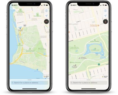
ios12newmapssf
The overall look and feel of ‌Apple Maps‌ is mostly the same, but zooming and panning reveals more details like grass, trees, sports fields, and parking lots. Apple also said search results would become more relevant.

Popular Stories

AirPods Max 2 Feature

Apple Announces AirPods Max 2 With H2 Chip and More

Monday March 16, 2026 6:12 am PDT by
Apple today unveiled AirPods Max 2, with key upgrades including the H2 chip, increased active noise cancellation, improved sound quality, and features such as Adaptive Audio, Conversation Awareness, Voice Isolation, and Live Translation. The new AirPods Max have the same overall design as the previous generation, with most of the new features coming from the upgrade to the H2 chip:- Adaptive ...
Apple Logo Sketch Feature

Apple Unveiled a Surprise New Product Today

Monday March 16, 2026 10:50 am PDT by
Surprise! Apple today unveiled the AirPods Max 2, despite no rumors suggesting that a new version of Apple's over-ear headphones were imminent. Key upgrades compared to the previous AirPods Max include Apple's H2 chip, increased active noise cancellation, improved sound quality, and features such as Adaptive Audio, Conversation Awareness, Voice Isolation, and Live Translation. AirPods Max ...
apple design award 2025

Apple Announces 2025 Design Award Winners Ahead of WWDC 2025

Tuesday June 3, 2025 10:14 am PDT by
As we wait for WWDC to kick off next Monday, Apple today announced the winners of its annual Apple Design Awards, recognizing apps and games for their innovation, ingenuity, and technical achievement. The 2025 Apple Design Award winners are listed below, with one app and one game selected per category: Delight and Fun - CapWords (App) and Balatro (Game) Innovation - Play (App) and PBJ -...

Top Rated Comments

AngerDanger Avatar
93 months ago
Apple also deployed employees wearing LiDAR-equipped backpacks ('https://www.macrumors.com/2018/10/12/apple-maps-san-francisco-survey-on-foot/') to collect pedestrian-based data starting in California late last year.
Still not entirely convinced those weren't inventors disguising their jetpacks by slapping an Apple Maps sticker on.


Attachment Image
Score: 9 Votes (Like | Disagree)
93 months ago
If only they had something similar to Street View coming out. Maybe call it Eye level or something.
iLevel o_O
Score: 7 Votes (Like | Disagree)
MozMan68 Avatar
93 months ago
I earnestly tried Apple Maps a couple years ago and it often would ignore portions of main roads thereby sending me on circular back-country journeys. Every time I used Apple Maps something strange would happen. I gave up and went back to using Google Maps.

Navigation accuracy is more important than streetscapes.
A lot has changed in a couple of years...
Score: 5 Votes (Like | Disagree)
93 months ago
As a map geek i love this.
Me too. This was a fascinating dive into Apple Maps and Google Maps -- and specifically the latest detail updates to Apple Maps.

https://www.justinobeirne.com/new-apple-maps

Definitely confirms what I've generally experienced: Apple Maps is getting quite good for wayfinding, but lags Google in place and business labelling.

Looks like this guy posts about once a year on the topic of digital app-based maps -- wish it was more!
Score: 4 Votes (Like | Disagree)
ghostface147 Avatar
93 months ago
If only they had something similar to Street View coming out. Maybe call it Eye level or something.
Score: 3 Votes (Like | Disagree)
93 months ago
As a map geek i love this.
Score: 2 Votes (Like | Disagree)