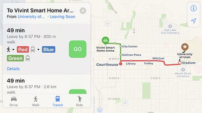
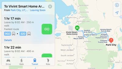
Apple Maps has been updated with comprehensive transit data for Salt Lake City, Utah, enabling iPhone users in the city and certain suburbs to navigate using Utah Transit Authority public transportation, including the TRAX light rail system, FrontRunner commuter train, S-Line streetcar, and buses.
Apple introduced Transit in Maps as part of iOS 9 in select cities around the world, including Baltimore, Berlin, Boston, Chicago, London, Los Angeles, Mexico City, New York, Philadelphia, San Francisco, Sydney, Toronto, and over 300 cities in China. The feature has its own tab in Apple Maps on iOS 10 when entering directions.
Transit routing is now available in several other cities around the world, including Atlanta, Columbus, Dallas-Fort Worth, Denver, Honolulu, Kansas City, Melbourne, Miami, Minneapolis–Saint Paul, Montréal, Pittsburgh, Portland, Prague, Rio de Janeiro, Sacramento, San Antonio, San Diego, and Seattle.
(Thanks, Bernd!)


Top Rated Comments
http://appleinsider.com/articles/16/07/07/why-apples-transit-maps-are-rolling-out-so-slowly
[doublepost=1481674780][/doublepost]WTH are you talking about?