Apple Expands Transit Directions to New Areas, Introduces More Indoor Maps for Malls and Airports - MacRumors
Skip to Content

Apple Expands Transit Directions to New Areas, Introduces More Indoor Maps for Malls and Airports

by

Transit directions for Apple Maps have recently expanded to encompass the entirety of multiple states and countries, Apple today confirmed in an update to its Feature Availability page.

Transit directions are now available across all of Alaska, Connecticut, Delaware, Florida, Georgia, Indiana, Illinois, Kentucky, Mississippi, Missouri, New Jersey, North Dakota, New York, Oklahoma, Rhode Island, South Dakota, and Texas.

apple maps indoor
In many of these locations, transit information has been available for a few weeks, but Apple is often slow to confirm with updates to its Feature Availability page. Several of the above-listed locations also had transit directions in a few major cities, but transit information is now available statewide.

Transit directions have also expanded to encompass all of Australia, and as was discovered in January, transit information is available in Denmark, Finland, Norway, and Sweden.

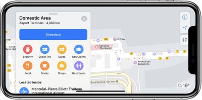
Apple has introduced indoor maps three new airports, including Fort Lauderdale-Hollywood International Airport (FLL), Newcastle International Airport (NCL), and Milano Linate Airport (LIN).

Indoor maps have also expanded to quite a few malls in the cities listed below:

  • Bellingham, WA
  • Bloomington, IN
  • Boulder, CO
  • Brookvale, Australia
  • Burwood, Australia
  • Carindale, Australia
  • Cheltenham, Australia
  • Chermside, Australia
  • Castel Guelfo di Bologna, Italy
  • Chiyoda, Japan
  • Denver, CO
  • Eastgardens, Australia
  • Edinburgh, IN
  • Evansville, IN
  • Greenwood, IN
  • Hoover, AL
  • Hornsby, Australia
  • Hurstville, Australia
  • Jonesboro, AR
  • Lakewood, CO
  • Littleton, CO
  • Liverpool, Australia
  • Lone Tree, CO
  • Lynnwood, WA
  • Manchester, NH
  • Merrimack, Australia
  • Miranda, Australia
  • Minato-Ku, Japan
  • Moline, IL
  • North Little Rock, AR
  • Parramatta, Australia
  • Penrith, Australia
  • Rogers, AR
  • Salem, NH
  • Seattle, WA
  • Shibuya, Japan
  • Spokane Valley, WA
  • Spokane, WA
  • Suita-Shi, Japan
  • Sydney, Australia
  • Toshima, Japan
  • Upper Mount Gravatt, Australia
  • Vancouver, WA
  • Vicolungo, Italy

Indoor maps for malls and airports were introduced in iOS 11, providing full layouts of each mall or airport location with icons for restaurants, elevators, bathrooms, shops, and other notable landmarks. Different floors are clearly marked, making it easy to navigate through unknown areas.

A full list of all of the airports and mall locations where the ‌Apple Maps‌ indoor mapping feature is available can be found on Apple's Feature Availability website, which also houses a list of all of the locations where transit directions are available.

Top Rated Comments

szw-mapple fan Avatar
97 months ago
Is that picture really what maps looks like in landscape mode? Has apple not updated it so the buttons aren’t obscured by the notch?
No, it's not. It just a X frame that was poorly superimposed on a iPhone 8 Plus screenshot. This ('https://appleinsider.com/articles/18/12/20/apple-maps-could-get-easier-to-use-on-the-iphone-with-arkit-advancements') is more accurate.
Score: 2 Votes (Like | Disagree)
ipedro Avatar
97 months ago
That seems like quite a random sampling of malls from around the world. How does Apple decide which malls to list - do the mall operators have to pay-to-play?
They don’t pay but mall operators do need to be involved. I think you’ll find that of the malls listed, they’re probably operated by many of the same property managers.
Score: 2 Votes (Like | Disagree)
MozMan68 Avatar
97 months ago
My local transit system (HART) in Connecticut is not included. So I think Apple is overstating this a bit.
...but CT Rail is...I'm not sure every city gets the same level of "transit" like NYC or SF does.

But yeah, I would think HART should be in there based on what they said.

edit: CT Transit (bus) also comes up.

edit #2: Google Maps doesn't show HART either though...I'm guessing it has something to do with HART and not the mapping systems. They have to agree to share their info.
Score: 1 Votes (Like | Disagree)
97 months ago
Is that picture really what maps looks like in landscape mode? Has apple not updated it so the buttons aren’t obscured by the notch?
Nobody will ever know for sure. They turned it the wrong way and committed a felony the world over. Some things like that are law. The top of the phone falls left, by law. Just like brushing your teeth requires you to wet the brush, apply the toothpaste, and wet that boy again before brushing. Law.
Score: 1 Votes (Like | Disagree)
97 months ago
Is that picture really what maps looks like in landscape mode? Has apple not updated it so the buttons aren’t obscured by the notch?
They're holding it wrong!
Score: 1 Votes (Like | Disagree)
97 months ago
I don't have a problem with those buttons.
Score: 1 Votes (Like | Disagree)

Popular Stories

Apple Maps General

Apple Maps Flyover Gets a Visual Upgrade in iOS 27

Monday June 8, 2026 4:29 pm PDT by
Apple Maps is getting a visual update in iOS 27, with Apple planning to introduce new aerial imagery that's combined with Visual Intelligence models. Apple said everything will have sharper detail, from the "shapes of individual trees to the way light reflects off the glass of skyscrapers." Flyover is an Apple Maps view that lets users see more than 350 cities in 3D with detailed...
Apple Says iOS 27 Adds These 12 New Features to Your iPhone Feature

Apple Says iOS 27 Adds These 12 New Features to Your iPhone

Tuesday June 9, 2026 9:47 am PDT by
iOS 27's key new feature is a more intelligent and personal version of Siri, but the changes go well beyond that. In a press release, Apple outlined additional enhancements coming across Apple Maps, Find My, Apple Wallet, Apple Music, and more. Apple Maps has gained an enhanced Flyover experience powered by AI, enabling you to view aerial imagery in "stunning detail" for select cities. In ...
liquid glass app icon

Apple Maps to Get These 10 New Features in iOS 27

Thursday June 11, 2026 5:45 am PDT by
Apple Maps is getting a range of new features in iOS 27, headlined by an upgraded Flyover experience that uses AI to improve the realism and detail of its aerial imagery. Flyover is a longstanding feature of Apple Maps and lets users explore more than 350 cities in 3D with detailed landmarks, roads, parks, and buildings. Apple described the enhanced Flyover in iOS 27 as combining aerial...