
Apple Maps Now Supports Transit in North Carolina - MacRumors
Skip to Content

Apple Maps Now Supports Transit in North Carolina

by

Apple Maps now supports transit in North Carolina, enabling users to navigate with public transportation in several metropolitan areas across the state.
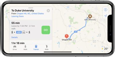
apple maps transit north carolina
The largest transit options supported include CATS buses and LYNX trains in the Charlotte area, GoTransit buses in the Raleigh-Durham-Chapel Hill area, GTA buses in Greensboro, and inter-city PART buses in the Piedmont Triad area.

Apple Maps also appears to support transit directions in a few additional areas of California, including Bakersfield and Fresno, complementing the previously supported areas of Los Angeles, San Francisco, San Diego, and others.

The feature can be accessed by tapping the Transit tab or button in Apple Maps on iPhone, iPad, Mac, or Apple Watch.

Apple Maps has supported transit since 2015, with an initial rollout in Baltimore, Berlin, Boston, Chicago, London, Los Angeles, Mexico City, New York, Philadelphia, San Francisco, Sydney, Toronto, and China. Since then, Apple has expanded the feature to dozens of additional cities around the world.

Google Maps has also supported navigation via public transportation for several years now, including in the Charlotte, Raleigh, and Greensboro areas, but Apple Maps is slowly catching up with detailed routing info.

In related news, Apple at its WWDC keynote on Monday announced that CarPlay will support Google Maps, Waze, and other third-party navigation apps with a paired iPhone running iOS 12, released in beta yesterday.

(Thanks, Ram!)
Top Rated Comments

MacLawyer Avatar
108 months ago
“As somebody who has lived in NC for 11 years, I am shocked by this. There is a public transport system in North Carolina?”

No. That’s why it was easy to support NC in the maps. :D
Score: 5 Votes (Like | Disagree)
108 months ago
As somebody who has lived in NC for 11 years, I am shocked by this. There is a public transport system in North Carolina?
Score: 2 Votes (Like | Disagree)
shadowbird423 Avatar
108 months ago
I use to live there and I didn't remember ever seeing a bus between cities. Traffic was bad so maybe they added it. Have not lived there in 17 years. I really liked downtime Chapel Hill with all the little mom & pop places to eat and shop.
Franklin Street has 2 or so Mom & Pops left. Spanky's just rebranded, Carolina Coffee Shop has new owners, Suttons' pharmacy got bought out by CVS (they still serve food) and the rest of the street is turning real commercial real quick. Restaurants are arriving and leaving within a year because the rent is too high It's a shame.

Go to Linda's Bar & Grill if you ever go back. Great bar and regular food and a good atmosphere.
Score: 1 Votes (Like | Disagree)
108 months ago
Please correct your article to read that Apple Maps transit now covers thousands of cities. You are making the mistake of referring to cities when Apple Maps transit has always covered entire regions, and now some entire countries.
Score: 1 Votes (Like | Disagree)
BornAgainMac Avatar
108 months ago
I use to live there and I didn't remember ever seeing a bus between cities. Traffic was bad so maybe they added it. Have not lived there in 17 years. I really liked downtime Chapel Hill with all the little mom & pop places to eat and shop.
Score: 1 Votes (Like | Disagree)

Popular Stories

trump lake america

Apple Maps Renames Lake Ontario 'Lake America'

Tuesday September 1, 2026 1:58 pm PDT by
Apple Maps users in the United States will now see "Lake America" instead of "Lake Ontario" for the Great Lake on the border of Ontario and New York. The updated name is currently rolling out to iPhone, iPad, and Mac users. The Maps app still has the Lake Ontario label for the body of water, but tapping it now says "Lake America." Apple will likely change the label in the next few hours....
Apple Maps Google Maps Icons

Google Maps Showing 'Lake America' in U.S., Apple Maps Yet to Follow

Monday August 31, 2026 6:33 am PDT by
Google Maps users in the U.S. will now see the name "Lake America" instead of "Lake Ontario" for the Great Lake that straddles the New York—Ontario border. Google said it made this change in response to the U.S. Geographic Names Information System (GNIS) updating the name for "Lake Ontario" to "Lake America," following an executive order issued by U.S. President Donald Trump last week....
apple maps ads live

Apple Maps Ads Are Here, and There's No Way to Turn Them Off

Tuesday August 25, 2026 1:40 pm PDT by
Ads in Apple Maps are live in the United States and Canada, which means iPhone and iPad users will see them when searching for locations and when viewing Suggested Places. Apple announced plans to bring ads to the Maps app in March, and said the feature would roll out starting in late summer. Apple confirmed to 9to5Mac that ads began showing up for users over the last few days, with ad...