
Apple Maps Expands Transit Data to San Diego and British Columbia - MacRumors
Skip to Content

Apple Maps Expands Transit Data to San Diego and British Columbia

by

Apple recently updated its Maps app to include transit information in San Diego, California and British Columbia, Canada allowing iOS users in those locations to incorporate public transportation options when seeking directions through the Apple Maps app.

In San Diego, Apple Maps will now offer up routes that include transportation by the city's Trolley, which connects the east and south counties with the Downtown area. The Trolley is San Diego's light rail system and sole public transportation option besides buses.
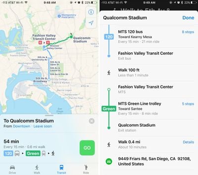
applemapstransit
In Vancouver, Victoria, and other cities in British Columbia, Canada, Apple Maps directions now incorporate the SkyTrain and other rail lines. Transit directions should be a welcome addition in Vancouver, which is Canada's third-largest metropolitan area.

Transit directions were first added to Apple Maps in 2015 as part of iOS 9. At launch, transit information was only available in a handful of cities, but Apple has been working hard to expand the feature to additional locations.

Transit data is now available in more than 20 cities around the world, along with dozens of cities in China.
Top Rated Comments

132 months ago
"Transit data is now available ('https://www.macrumors.com/2015/09/16/ios-9-apple-maps-transit-nearby/') in more than 20 cities around the world"

Honestly that sounds so sad. What is the holdup? Seriously?
Score: 9 Votes (Like | Disagree)
132 months ago
Professionals cost money!
Facts- While over two hundred million people are now in areas covered by Apple Transit, along with a thousand cities, here's why Apple declined to simply throw the switch and turn them all one at once, ala Google.
-http://appleinsider.com/articles/16/07/07/why-apples-transit-maps-are-rolling-out-so-slowly
Score: 5 Votes (Like | Disagree)
132 months ago
"Transit data is now available ('https://www.macrumors.com/2015/09/16/ios-9-apple-maps-transit-nearby/') in more than 20 cities around the world"

Honestly that sounds so sad. What is the holdup? Seriously?
Once again the bashing is so ill informed. Each of the "cities" covered are actually large metropolitan areas with over two hundred million people and over a thousand cities. Apple could turn on entire countries right away like Google did, but as they have explained, they are customizing each area for a better user experience, something Google declined to do.
Score: 5 Votes (Like | Disagree)
132 months ago
"Transit data is now available ('https://www.macrumors.com/2015/09/16/ios-9-apple-maps-transit-nearby/') in more than 20 cities around the world"

Honestly that sounds so sad. What is the holdup? Seriously?
Watch bands.
Score: 4 Votes (Like | Disagree)
SBlue1 Avatar
132 months ago
Transit data is now available ('https://www.macrumors.com/2015/09/16/ios-9-apple-maps-transit-nearby/') in more than 20 cities around the world
20 worldwide???? Is this a joke?? Should be more like 20 thousand by now... Man, how big is the maps team? One poor guy?
Score: 3 Votes (Like | Disagree)
132 months ago
As someone who lives in the suburbs of San Diego, this is nice, but public transportation is pretty poor and not widely utilized here.
That is incorrect. San Diego public transit has 85 million riders annually.
Score: 2 Votes (Like | Disagree)

Popular Stories

trump lake america

Apple Maps Renames Lake Ontario 'Lake America'

Tuesday September 1, 2026 1:58 pm PDT by
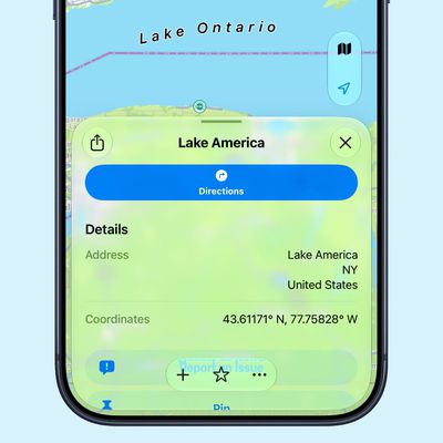
Apple Maps users in the United States will now see "Lake America" instead of "Lake Ontario" for the Great Lake on the border of Ontario and New York. The updated name is currently rolling out to iPhone, iPad, and Mac users. The Maps app still has the Lake Ontario label for the body of water, but tapping it now says "Lake America." Apple will likely change the label in the next few hours....
Apple Maps Google Maps Icons

Google Maps Showing 'Lake America' in U.S., Apple Maps Yet to Follow

Monday August 31, 2026 6:33 am PDT by
Google Maps users in the U.S. will now see the name "Lake America" instead of "Lake Ontario" for the Great Lake that straddles the New York—Ontario border. Google said it made this change in response to the U.S. Geographic Names Information System (GNIS) updating the name for "Lake Ontario" to "Lake America," following an executive order issued by U.S. President Donald Trump last week....
apple maps ads live

Apple Maps Ads Are Here, and There's No Way to Turn Them Off

Tuesday August 25, 2026 1:40 pm PDT by
Ads in Apple Maps are live in the United States and Canada, which means iPhone and iPad users will see them when searching for locations and when viewing Suggested Places. Apple announced plans to bring ads to the Maps app in March, and said the feature would roll out starting in late summer. Apple confirmed to 9to5Mac that ads began showing up for users over the last few days, with ad...