Google Maps Gains Enhanced Street-Level Detail in Four Major Cities
Google Maps has quietly been updated to include significantly more detailed street-level information in a handful of key cities around the world.
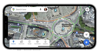
Upon zooming in, Google's maps for Central London, Tokyo, San Francisco, and New York now benefit from shapes and widths that match the scale of roads more accurately.
Meanwhile, enhanced graphical representations of sidewalks, crosswalks, pedestrian islands, and street-side flora have also been added, which should help users who rely on the maps for walking directions.
Lastly, parks now show the actual width of pathways in dark green along with any stairs in grey, offering improved accessibility information for wheelchair users or people with a stroller.
Some of the improvements are undoubtedly subtle, but underline Google's commitment to improving city-wide coverage. The changes are server-side and therefore require no software update, and Google says it plans to expand the new details to additional cities in the future.
Google Maps can be downloaded from the App Store for free. [Direct Link]
(Via AndroidPolice.)
Popular Stories
Apple has stopped production of FineWoven accessories, according to the Apple leaker and prototype collector known as "Kosutami." In a post on X (formerly Twitter), Kosutami explained that Apple has stopped production of FineWoven accessories due to its poor durability. The company may move to another non-leather material for its premium accessories in the future. Kosutami has revealed...
The lead developer of the multi-emulator app Provenance has told iMore that his team is working towards releasing the app on the App Store, but he did not provide a timeframe. Provenance is a frontend for many existing emulators, and it would allow iPhone and Apple TV users to emulate games released for a wide variety of classic game consoles, including the original PlayStation, GameCube, Wii,...
The upcoming iOS 17.5 update for the iPhone includes only a few new user-facing features, but hidden code changes reveal some additional possibilities. Below, we have recapped everything new in the iOS 17.5 and iPadOS 17.5 beta so far. Web Distribution Starting with the second beta of iOS 17.5, eligible developers are able to distribute their iOS apps to iPhone users located in the EU...
Apple Vision Pro, Apple's $3,500 spatial computing device, appears to be following a pattern familiar to the AR/VR headset industry – initial enthusiasm giving way to a significant dip in sustained interest and usage. Since its debut in the U.S. in February 2024, excitement for the Apple Vision Pro has noticeably cooled, according to Bloomberg's Mark Gurman. Writing in his latest Power On...
It was a big week for retro gaming fans, as iPhone users are starting to reap the rewards of Apple's recent change to allow retro game emulators on the App Store. This week also saw a new iOS 17.5 beta that will support web-based app distribution in the EU, the debut of the first hotels to allow for direct AirPlay streaming to room TVs, a fresh rumor about the impending iPad Air update, and...


Top Rated Comments
“Apple releases new 3D flyovers in four major cities. This is what everyone cares about - the flyovers. Right? RIGHT?!”
It has gotten so much better in the States that for the third time I am using it as my main navigation app, in the past I tried and it was just not on par with the competition, I can see the improvements now.
It still has a long way to go, they could work on:
1. Better handling of pins and coordinates, this is important for professionals like geologists, engineers, biologists, etc.
2. More detailed turn-by-turn navigation, it is still behind the precision and detail offered by Google Maps. Apple Maps sometimes tells me "the next exit" I have to take but it would not tell me the exit number, which is something I would like to know in advance.
3. Public transportation implementation. Even though I can find routes in my city, some of them are even routes that have been eliminated. In contrast Google Maps tells me exactly where the bus is in REAL TIME, I can literally track it and not just rely on an ETA.
4. And most importantly: OFFLINE functionality. Several mapping apps in the store offer me to download maps for offline usage, but Apple Maps will not let me do that, it is frustrating as I work on the field constantly and cellphone reception is not available most of the time.
they are free to take photos of my street and obscure faces and license plates just like google does.
That old trope that gets pedalled around here is so tired.